Palmoli geodata
Palmoli (Abruzzo) is a seat of a third-order administrative division; located in Italy in Europe/Rome (GMT+2) time zone. With population of 676 people, there are 8450 cities with bigger population in this country. Compared to other cities in Italy, 70.9% of cities are located further ↑North; 83.4% of cities are located further ←West and 89.4% of cities have lower elevation than Palmoli. Note1


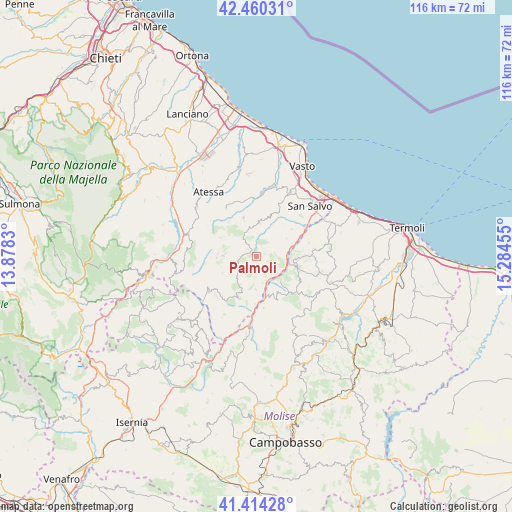
Palmoli GPS coordinates[2]
41° 56' 21.984" North, 14° 34' 53.112" East
| Map corner | latitude | longitude |
|---|---|---|
| Upper-left | 42.46031°, | 13.8783° |
| Center: | 41.93944°, | 14.58142° |
| Lower-right: | 41.41428°, | 15.28455° |
| Map W x H: | 116.3×116.3 km | = 72.3×72.3mi |
| max Lat: | 47.04031° ⇑70.9% North |
| Palmoli: | 41.93944° |
| min Lat: | ⇓29.1% South 35.50142° |
| min Long | Palmoli | max Long |
| 6.69888° | 14.58142° | 18.48682° |
| W 83.4%⇐ | ⇒16.6% E |
Elevation
Elevation of Palmoli is 703 m = 2306 ft, and this is 396.3 m = 1300 ft above average elevation for this country.
| Max E: |
2085 m = 6841 ft | 10.6% |
| Palmoli | 703 m 2306 ft | |
| Avg. | 306.7 m = 1006 ft | |
Min E: |
-4 m = -13 ft | 89.4% |
See also: Italy elevation on elevation.city.
Geographical zone
Palmoli is located in North temperate zone (between Tropic of Cancer and the Arctic Circle). Distance of this Northern Tropic circle is 2057.3 km =1278.3 mi to South.| Distance of | km | miles | from Palmoli |
|---|---|---|---|
| North Pole | 5343.8 | 3320.5 | to North |
| Arctic Circle | 2737.9 | 1701.3 | to North |
| Tropic Cancer | 2057.3 | 1278.3 | to South |
| Equator | 4663.2 | 2897.6 | to South |


Nearby cities:
15 places around Palmoli: (largest is in red/bold)
• Carunchio
5.1 km =3.2 mi,  241°
241°
• Celenza sul Trigno
7.5 km =4.7 mi,  181°
181°
• Dogliola
4.4 km =2.7 mi,  85°
85°
• Fraine
8.6 km =5.3 mi, 244°
• Fresagrandinaria
8 km =5 mi,  56°
56°
• Furci
7.6 km =4.7 mi,  4°
4°
• Gissi
9.2 km =5.7 mi,  340°
340°
• Lentella
10.1 km =6.3 mi,  51°
51°
• Liscia
2.8 km =1.7 mi,  309°
309°
• Montefalcone nel Sannio
9.4 km =5.8 mi,  149°
149°
• Montemitro
7.9 km =4.9 mi,  136°
136°
• Roccaspinalveti-Santa Giusta
9.1 km =5.7 mi,  272°
272°
• San Buono
4.8 km =3 mi,  346°
346°
• Torrebruna
8.7 km =5.4 mi,  202°
202°
• Tufillo
4.4 km =2.7 mi,  124°
124°
Sources, notices
• [Note1] Compared only with cities in Italy existing in our database
• [Src1] Map data: © OpenStreetMap contributors (CC-BY-SA)
• [Src2] Other city data from geonames.org with taken over terms of usage.
• [Src3] Geographical zone / Annual Mean Temperature by Robert A. Rohde @ Wikipedia
