Codevilla geodata
Codevilla (Lombardy) is a seat of a third-order administrative division; located in Italy in Europe/Rome (GMT+2) time zone. With population of 769 people, there are 7822 cities with bigger population in this country. Compared to other cities in Italy, 59.2% of cities are located further ↓South; 80.4% of cities are located further →East and 62% of cities have higher elevation than Codevilla. Note1


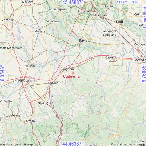
Codevilla GPS coordinates[2]
44° 57' 48.708" North, 9° 3' 27.828" East
| Map corner | latitude | longitude |
|---|---|---|
| Upper-left | 45.45887°, | 8.3546° |
| Center: | 44.96353°, | 9.05773° |
| Lower-right: | 44.46387°, | 9.76085° |
| Map W x H: | 110.6×110.6 km | = 68.7×68.7mi |
| max Lat: | 47.04031° ⇑40.8% North |
| Codevilla: | 44.96353° |
| min Lat: | ⇓59.2% South 35.50142° |
| min Long | Codevilla | max Long |
| 6.69888° | 9.05773° | 18.48682° |
| W 19.6%⇐ | ⇒80.4% E |
Elevation
Elevation of Codevilla is 149 m = 489 ft, and this is 157.7 m = 517 ft below average elevation for this country.
| Max E: |
2085 m = 6841 ft | 62% |
| Avg. | 306.7 m = 1006 ft | |
| Codevilla | 149 m = 489 ft | |
Min E: |
-4 m = -13 ft | 38% |
See also: Italy elevation on elevation.city.
Geographical zone
Codevilla is located in North temperate zone (between Tropic of Cancer and the Arctic Circle). Distance of this Northern Tropic circle is 2393.6 km =1487.3 mi to South.| Distance of | km | miles | from Codevilla |
|---|---|---|---|
| North Pole | 5007.6 | 3111.6 | to North |
| Arctic Circle | 2401.7 | 1492.3 | to North |
| Tropic Cancer | 2393.6 | 1487.3 | to South |
| Equator | 4999.5 | 3106.5 | to South |


Nearby cities:
15 places around Codevilla: (largest is in red/bold)
• Borgo Priolo
7.1 km =4.4 mi,  87°
87°
• Calvignano
9 km =5.6 mi,  76°
76°
• Casalnoceto
8.1 km =5 mi,  226°
226°
• Casteggio
7.7 km =4.8 mi,  43°
43°
• Godiasco
7.5 km =4.7 mi,  180°
180°
• Lungavilla
8.8 km =5.5 mi,  10°
10°
• Montebello
5.4 km =3.4 mi, 41°
• Montesegale
8.3 km =5.2 mi,  139°
139°
• Pizzale
8.4 km =5.2 mi,  355°
355°
• Retorbido
2.2 km =1.4 mi, 227°
• Rivanazzano
5.2 km =3.2 mi,  222°
222°
• Salice Terme
5.9 km =3.7 mi,  204°
204°
• Susella
6.4 km =4 mi,  151°
151°
• Torrazza Coste
2.2 km =1.4 mi, 41°
• Voghera
4.8 km =3 mi,  310°
310°
Sources, notices
• [Note1] Compared only with cities in Italy existing in our database
• [Src1] Map data: © OpenStreetMap contributors (CC-BY-SA)
• [Src2] Other city data from geonames.org with taken over terms of usage.
• [Src3] Geographical zone / Annual Mean Temperature by Robert A. Rohde @ Wikipedia
