Raiano geodata
Raiano (Abruzzo) is a seat of a third-order administrative division; located in Italy in Europe/Rome (GMT+2) time zone. With population of 2,726 people, there are 3288 cities with bigger population in this country. Compared to other cities in Italy, 69.5% of cities are located further ↑North; 76.7% of cities are located further ←West and 69.6% of cities have lower elevation than Raiano. Note1


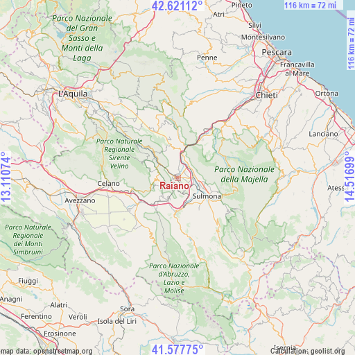
Raiano GPS coordinates[2]
42° 6' 5.688" North, 13° 48' 49.896" East
| Map corner | latitude | longitude |
|---|---|---|
| Upper-left | 42.62112°, | 13.11074° |
| Center: | 42.10158°, | 13.81386° |
| Lower-right: | 41.57775°, | 14.51699° |
| Map W x H: | 116×116 km | = 72.1×72.1mi |
| max Lat: | 47.04031° ⇑69.5% North |
| Raiano: | 42.10158° |
| min Lat: | ⇓30.5% South 35.50142° |
| min Long | Raiano | max Long |
| 6.69888° | 13.81386° | 18.48682° |
| W 76.7%⇐ | ⇒23.3% E |
Elevation
Elevation of Raiano is 390 m = 1280 ft, and this is 83.3 m = 273 ft above average elevation for this country.
| Max E: |
2085 m = 6841 ft | 30.4% |
| Raiano | 390 m 1280 ft | |
| Avg. | 306.7 m = 1006 ft | |
Min E: |
-4 m = -13 ft | 69.6% |
See also: Italy elevation on elevation.city.
Geographical zone
Raiano is located in North temperate zone (between Tropic of Cancer and the Arctic Circle). Distance of this Northern Tropic circle is 2075.3 km =1289.5 mi to South.| Distance of | km | miles | from Raiano |
|---|---|---|---|
| North Pole | 5325.8 | 3309.3 | to North |
| Arctic Circle | 2719.9 | 1690.1 | to North |
| Tropic Cancer | 2075.3 | 1289.5 | to South |
| Equator | 4681.3 | 2908.8 | to South |


Nearby cities:
15 places around Raiano: (largest is in red/bold)
• Badia
8.6 km =5.3 mi,  98°
98°
• Bugnara
9.5 km =5.9 mi,  155°
155°
• Castel di Ieri
6.1 km =3.8 mi,  282°
282°
• Castelvecchio Subequo
7.7 km =4.8 mi,  293°
293°
• Cocullo
8.3 km =5.2 mi,  202°
202°
• Corfinio
3.1 km =1.9 mi,  43°
43°
• Gagliano Aterno
9.8 km =6.1 mi, 286°
• Goriano Sicoli
4 km =2.5 mi,  233°
233°
• Molina Aterno
8.3 km =5.2 mi,  309°
309°
• Popoli
7.6 km =4.7 mi,  10°
10°
• Pratola Peligna
5 km =3.1 mi, 95°
• Prezza
5.2 km =3.2 mi, 159°
• Roccacasale
6.5 km =4 mi,  69°
69°
• San Benedetto in Perillis
9.8 km =6.1 mi,  338°
338°
• Vittorito
2.8 km =1.7 mi,  4°
4°
Sources, notices
• [Note1] Compared only with cities in Italy existing in our database
• [Src1] Map data: © OpenStreetMap contributors (CC-BY-SA)
• [Src2] Other city data from geonames.org with taken over terms of usage.
• [Src3] Geographical zone / Annual Mean Temperature by Robert A. Rohde @ Wikipedia
