Badia geodata
Badia (Abruzzo) is a populated place; located in Italy in Europe/Rome (GMT+2) time zone. With population of 847 people, there are 7418 cities with bigger population in this country. Compared to other cities in Italy, 69.6% of cities are located further ↑North; 77.6% of cities are located further ←West and 67.2% of cities have lower elevation than Badia. Note1


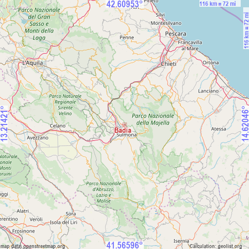
Badia GPS coordinates[2]
42° 5' 23.604" North, 13° 55' 2.388" East
| Map corner | latitude | longitude |
|---|---|---|
| Upper-left | 42.60953°, | 13.21421° |
| Center: | 42.08989°, | 13.91733° |
| Lower-right: | 41.56596°, | 14.62046° |
| Map W x H: | 116×116 km | = 72.1×72.1mi |
| max Lat: | 47.04031° ⇑69.6% North |
| Badia: | 42.08989° |
| min Lat: | ⇓30.4% South 35.50142° |
| min Long | Badia | max Long |
| 6.69888° | 13.91733° | 18.48682° |
| W 77.6%⇐ | ⇒22.4% E |
Elevation
Elevation of Badia is 365 m = 1198 ft, and this is 58.3 m = 191 ft above average elevation for this country.
| Max E: |
2085 m = 6841 ft | 32.8% |
| Badia | 365 m 1198 ft | |
| Avg. | 306.7 m = 1006 ft | |
Min E: |
-4 m = -13 ft | 67.2% |
See also: Italy elevation on elevation.city.
Geographical zone
Badia is located in North temperate zone (between Tropic of Cancer and the Arctic Circle). Distance of this Northern Tropic circle is 2074 km =1288.7 mi to South.| Distance of | km | miles | from Badia |
|---|---|---|---|
| North Pole | 5327.1 | 3310.1 | to North |
| Arctic Circle | 2721.2 | 1690.9 | to North |
| Tropic Cancer | 2074 | 1288.7 | to South |
| Equator | 4680 | 2908 | to South |


Nearby cities:
15 places around Badia: (largest is in red/bold)
• Bugnara
8.7 km =5.4 mi,  212°
212°
• Caramanico Terme
10.3 km =6.4 mi,  44°
44°
• Corfinio
7.3 km =4.5 mi,  298°
298°
• Introdacqua
9.1 km =5.7 mi,  190°
190°
• Marane
3.8 km =2.4 mi,  139°
139°
• Pacentro
7.5 km =4.7 mi,  125°
125°
• Popoli
11.3 km =7 mi,  320°
320°
• Pratola Peligna
3.6 km =2.2 mi,  282°
282°
• Prezza
7.6 km =4.7 mi,  242°
242°
• Raiano
8.6 km =5.3 mi, 278°
• Roccacasale
4.4 km =2.7 mi,  325°
325°
• Salle
10.4 km =6.5 mi,  20°
20°
• Sant'Eufemia a Maiella
9.9 km =6.2 mi,  65°
65°
• Sulmona
4.6 km =2.9 mi,  171°
171°
• Vittorito
9.3 km =5.8 mi, 296°
Sources, notices
• [Note1] Compared only with cities in Italy existing in our database
• [Src1] Map data: © OpenStreetMap contributors (CC-BY-SA)
• [Src2] Other city data from geonames.org with taken over terms of usage.
• [Src3] Geographical zone / Annual Mean Temperature by Robert A. Rohde @ Wikipedia
