Pray geodata
Pray (Piedmont) is a seat of a third-order administrative division; located in Italy in Europe/Rome (GMT+2) time zone. With population of 1,408 people, there are 5337 cities with bigger population in this country. Compared to other cities in Italy, 80.1% of cities are located further ↓South; 91% of cities are located further →East and 72.7% of cities have lower elevation than Pray. Note1


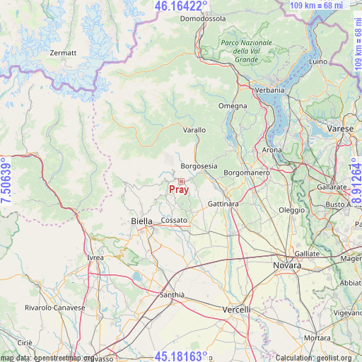
Pray GPS coordinates[2]
45° 40' 30.288" North, 8° 12' 34.236" East
| Map corner | latitude | longitude |
|---|---|---|
| Upper-left | 46.16422°, | 7.50639° |
| Center: | 45.67508°, | 8.20951° |
| Lower-right: | 45.18163°, | 8.91264° |
| Map W x H: | 109.3×109.3 km | = 67.9×67.9mi |
| max Lat: | 47.04031° ⇑19.9% North |
| Pray: | 45.67508° |
| min Lat: | ⇓80.1% South 35.50142° |
| min Long | Pray | max Long |
| 6.69888° | 8.20951° | 18.48682° |
| W 9%⇐ | ⇒91% E |
Elevation
Elevation of Pray is 422 m = 1385 ft, and this is 115.3 m = 378 ft above average elevation for this country.
| Max E: |
2085 m = 6841 ft | 27.3% |
| Pray | 422 m 1385 ft | |
| Avg. | 306.7 m = 1006 ft | |
Min E: |
-4 m = -13 ft | 72.7% |
See also: Italy elevation on elevation.city.
Geographical zone
Pray is located in North temperate zone (between Tropic of Cancer and the Arctic Circle). Distance of this North polar circle is 2322.6 km =1443.2 mi to North.| Distance of | km | miles | from Pray |
|---|---|---|---|
| North Pole | 4928.5 | 3062.4 | to North |
| Arctic Circle | 2322.6 | 1443.2 | to North |
| Tropic Cancer | 2472.7 | 1536.5 | to South |
| Equator | 5078.6 | 3155.7 | to South |


Nearby cities:
15 places around Pray: (largest is in red/bold)
• Ailoche
2.7 km =1.7 mi,  19°
19°
• Coggiola
2.4 km =1.5 mi,  300°
300°
• Crevacuore
2.9 km =1.8 mi,  66°
66°
• Crocemosso
5.6 km =3.5 mi,  231°
231°
• Curino
5.7 km =3.5 mi,  158°
158°
• Frazione Chiesa
2.1 km =1.3 mi,  5°
5°
• Giardino-Botto
4.4 km =2.7 mi,  238°
238°
• Guardabosone
4.3 km =2.7 mi,  46°
46°
• Lanvario
4 km =2.5 mi,  192°
192°
• Mezzana Mortigliengo
5.6 km =3.5 mi,  196°
196°
• Portula
2.9 km =1.8 mi,  270°
270°
• Postua
4.5 km =2.8 mi, 19°
• Soprana
4 km =2.5 mi, 191°
• Sostegno
5.3 km =3.3 mi,  117°
117°
• Trivero-Prativero-Ponzone
3.2 km =2 mi, 239°
Sources, notices
• [Note1] Compared only with cities in Italy existing in our database
• [Src1] Map data: © OpenStreetMap contributors (CC-BY-SA)
• [Src2] Other city data from geonames.org with taken over terms of usage.
• [Src3] Geographical zone / Annual Mean Temperature by Robert A. Rohde @ Wikipedia
