Possagno geodata
Possagno (Veneto) is a seat of a third-order administrative division; located in Italy in Europe/Rome (GMT+2) time zone. With population of 2,110 people, there are 3970 cities with bigger population in this country. Compared to other cities in Italy, 87.6% of cities are located further ↓South; 54.3% of cities are located further ←West and 50% of cities have lower elevation than Possagno. Note1


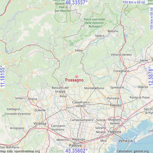
Possagno GPS coordinates[2]
45° 50' 52.62" North, 11° 53' 4.812" East
| Map corner | latitude | longitude |
|---|---|---|
| Upper-left | 46.33557°, | 11.18155° |
| Center: | 45.84795°, | 11.88467° |
| Lower-right: | 45.35602°, | 12.5878° |
| Map W x H: | 108.9×108.9 km | = 67.7×67.7mi |
| max Lat: | 47.04031° ⇑12.4% North |
| Possagno: | 45.84795° |
| min Lat: | ⇓87.6% South 35.50142° |
| min Long | Possagno | max Long |
| 6.69888° | 11.88467° | 18.48682° |
| W 54.3%⇐ | ⇒45.7% E |
Elevation
Elevation of Possagno is 235 m = 771 ft, and this is 71.7 m = 235 ft below average elevation for this country.
| Max E: |
2085 m = 6841 ft | 50% |
| Avg. | 306.7 m = 1006 ft | |
| Possagno | 235 m = 771 ft | |
Min E: |
-4 m = -13 ft | 50% |
See also: Italy elevation on elevation.city.
Geographical zone
Possagno is located in North temperate zone (between Tropic of Cancer and the Arctic Circle). Distance of this North polar circle is 2303.4 km =1431.3 mi to North.| Distance of | km | miles | from Possagno |
|---|---|---|---|
| North Pole | 4909.2 | 3050.4 | to North |
| Arctic Circle | 2303.4 | 1431.3 | to North |
| Tropic Cancer | 2491.9 | 1548.4 | to South |
| Equator | 5097.8 | 3167.6 | to South |


Nearby cities:
15 places around Possagno: (largest is in red/bold)
• Alano di Piave
6.8 km =4.2 mi,  15°
15°
• Asolo
7.1 km =4.4 mi,  159°
159°
• Caniezza
1.2 km =0.7 mi,  64°
64°
• Castelcucco
2 km =1.2 mi,  183°
183°
• Cavaso del Tomba
1.8 km =1.1 mi,  36°
36°
• Crespano del Grappa
4.5 km =2.8 mi,  240°
240°
• Crespignaga
7.5 km =4.7 mi,  143°
143°
• Fonte Alto
5.4 km =3.4 mi,  198°
198°
• Monfumo
3.4 km =2.1 mi,  124°
124°
• Onè
7.2 km =4.5 mi,  186°
186°
• Paderno
3.1 km =1.9 mi,  224°
224°
• Paderno del Grappa
3 km =1.9 mi, 224°
• Pagnano
4.4 km =2.7 mi, 175°
• Pederobba
5.9 km =3.7 mi, 58°
• Sant'Eulalia
6.4 km =4 mi, 236°
Sources, notices
• [Note1] Compared only with cities in Italy existing in our database
• [Src1] Map data: © OpenStreetMap contributors (CC-BY-SA)
• [Src2] Other city data from geonames.org with taken over terms of usage.
• [Src3] Geographical zone / Annual Mean Temperature by Robert A. Rohde @ Wikipedia
