Crespignaga geodata
Crespignaga (Veneto) is a populated place; located in Italy in Europe/Rome (GMT+2) time zone. With population of 896 people, there are 7175 cities with bigger population in this country. Compared to other cities in Italy, 85.5% of cities are located further ↓South; 55.1% of cities are located further ←West and 67.8% of cities have higher elevation than Crespignaga. Note1


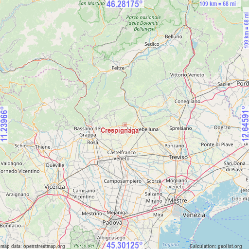
Crespignaga GPS coordinates[2]
45° 47' 37.176" North, 11° 56' 34.008" East
| Map corner | latitude | longitude |
|---|---|---|
| Upper-left | 46.28175°, | 11.23966° |
| Center: | 45.79366°, | 11.94278° |
| Lower-right: | 45.30125°, | 12.64591° |
| Map W x H: | 109×109 km | = 67.7×67.7mi |
| max Lat: | 47.04031° ⇑14.5% North |
| Crespignaga: | 45.79366° |
| min Lat: | ⇓85.5% South 35.50142° |
| min Long | Crespignaga | max Long |
| 6.69888° | 11.94278° | 18.48682° |
| W 55.1%⇐ | ⇒44.9% E |
Elevation
Elevation of Crespignaga is 110 m = 361 ft, and this is 196.7 m = 645 ft below average elevation for this country.
| Max E: |
2085 m = 6841 ft | 67.8% |
| Avg. | 306.7 m = 1006 ft | |
| Crespignaga | 110 m = 361 ft | |
Min E: |
-4 m = -13 ft | 32.2% |
See also: Italy elevation on elevation.city.
Geographical zone
Crespignaga is located in North temperate zone (between Tropic of Cancer and the Arctic Circle). Distance of this North polar circle is 2309.4 km =1435 mi to North.| Distance of | km | miles | from Crespignaga |
|---|---|---|---|
| North Pole | 4915.3 | 3054.2 | to North |
| Arctic Circle | 2309.4 | 1435 | to North |
| Tropic Cancer | 2485.9 | 1544.7 | to South |
| Equator | 5091.8 | 3163.9 | to South |


Nearby cities:
15 places around Crespignaga: (largest is in red/bold)
• Altivole
4.6 km =2.9 mi,  166°
166°
• Asolo
2.1 km =1.3 mi,  254°
254°
• Caerano di San Marco
4.5 km =2.8 mi,  107°
107°
• Caselle
5.7 km =3.5 mi,  149°
149°
• Castelcucco
6.2 km =3.9 mi,  311°
311°
• Cornuda
6.5 km =4 mi,  49°
49°
• Fonte Alto
6.3 km =3.9 mi,  278°
278°
• Maser
2.9 km =1.8 mi,  58°
58°
• Monfumo
4.5 km =2.8 mi,  337°
337°
• Muliparte
4.1 km =2.5 mi, 52°
• Onè
5.4 km =3.4 mi,  258°
258°
• Pagnano
4.5 km =2.8 mi,  291°
291°
• San Vito
4.8 km =3 mi,  206°
206°
• Spineda
6.9 km =4.3 mi,  226°
226°
• Villa d'Asolo
4.1 km =2.5 mi, 234°
Sources, notices
• [Note1] Compared only with cities in Italy existing in our database
• [Src1] Map data: © OpenStreetMap contributors (CC-BY-SA)
• [Src2] Other city data from geonames.org with taken over terms of usage.
• [Src3] Geographical zone / Annual Mean Temperature by Robert A. Rohde @ Wikipedia
