Onè geodata
Onè (Veneto) is a seat of a third-order administrative division; located in Italy in Europe/Rome (GMT+2) time zone. With population of 4,009 people, there are 2390 cities with bigger population in this country. Compared to other cities in Italy, 85.1% of cities are located further ↓South; 54.2% of cities are located further ←West and 69% of cities have higher elevation than Onè. Note1


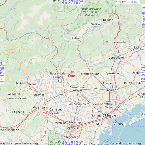
Onè GPS coordinates[2]
45° 47' 1.464" North, 11° 52' 26.544" East
| Map corner | latitude | longitude |
|---|---|---|
| Upper-left | 46.27192°, | 11.17092° |
| Center: | 45.78374°, | 11.87404° |
| Lower-right: | 45.29125°, | 12.57717° |
| Map W x H: | 109×109 km | = 67.7×67.7mi |
| max Lat: | 47.04031° ⇑14.9% North |
| Onè: | 45.78374° |
| min Lat: | ⇓85.1% South 35.50142° |
| min Long | Onè | max Long |
| 6.69888° | 11.87404° | 18.48682° |
| W 54.2%⇐ | ⇒45.8% E |
Elevation
Elevation of Onè is 103 m = 338 ft, and this is 203.7 m = 668 ft below average elevation for this country.
| Max E: |
2085 m = 6841 ft | 69% |
| Avg. | 306.7 m = 1006 ft | |
| Onè | 103 m = 338 ft | |
Min E: |
-4 m = -13 ft | 31% |
See also: Italy elevation on elevation.city.
Geographical zone
Onè is located in North temperate zone (between Tropic of Cancer and the Arctic Circle). Distance of this North polar circle is 2310.5 km =1435.7 mi to North.| Distance of | km | miles | from Onè |
|---|---|---|---|
| North Pole | 4916.4 | 3054.9 | to North |
| Arctic Circle | 2310.5 | 1435.7 | to North |
| Tropic Cancer | 2484.8 | 1544 | to South |
| Equator | 5090.7 | 3163.2 | to South |


Nearby cities:
15 places around Onè: (largest is in red/bold)
• Asolo
3.4 km =2.1 mi,  80°
80°
• Ca' Rainati
3.4 km =2.1 mi,  211°
211°
• Casoni
5.6 km =3.5 mi,  241°
241°
• Castelcucco
5.2 km =3.2 mi,  7°
7°
• Crespignaga
5.4 km =3.4 mi, 78°
• Fonte Alto
2.2 km =1.4 mi,  335°
335°
• Liedolo
4.3 km =2.7 mi,  282°
282°
• Mussolente
5.3 km =3.3 mi,  264°
264°
• Paderno
5.1 km =3.2 mi, 344°
• Paderno del Grappa
5.1 km =3.2 mi,  345°
345°
• Pagnano
3 km =1.9 mi,  22°
22°
• San Vito
4.5 km =2.8 mi,  134°
134°
• San Zenone degli Ezzelini
2.9 km =1.8 mi, 262°
• Spineda
3.7 km =2.3 mi,  175°
175°
• Villa d'Asolo
2.4 km =1.5 mi,  123°
123°
Sources, notices
• [Note1] Compared only with cities in Italy existing in our database
• [Src1] Map data: © OpenStreetMap contributors (CC-BY-SA)
• [Src2] Other city data from geonames.org with taken over terms of usage.
• [Src3] Geographical zone / Annual Mean Temperature by Robert A. Rohde @ Wikipedia
