Ponte A Elsa geodata
Ponte A Elsa (Tuscany) is a populated place; located in Italy in Europe/Rome (GMT+2) time zone. With population of 1,146 people, there are 6123 cities with bigger population in this country. Compared to other cities in Italy, 58.3% of cities are located further ↑North; 58.6% of cities are located further →East and 80.1% of cities have higher elevation than Ponte A Elsa. Note1


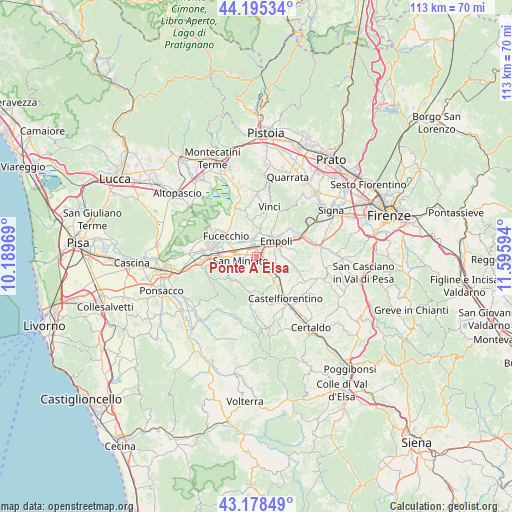
Ponte A Elsa GPS coordinates[2]
43° 41' 20.652" North, 10° 53' 34.116" East
| Map corner | latitude | longitude |
|---|---|---|
| Upper-left | 44.19534°, | 10.18969° |
| Center: | 43.68907°, | 10.89281° |
| Lower-right: | 43.17849°, | 11.59594° |
| Map W x H: | 113.1×113.1 km | = 70.3×70.3mi |
| max Lat: | 47.04031° ⇑58.3% North |
| Ponte A Elsa: | 43.68907° |
| min Lat: | ⇓41.7% South 35.50142° |
| min Long | Ponte A Elsa | max Long |
| 6.69888° | 10.89281° | 18.48682° |
| W 41.4%⇐ | ⇒58.6% E |
Elevation
Elevation of Ponte A Elsa is 49 m = 161 ft, and this is 257.7 m = 845 ft below average elevation for this country.
| Max E: |
2085 m = 6841 ft | 80.1% |
| Avg. | 306.7 m = 1006 ft | |
| Ponte A Elsa | 49 m = 161 ft | |
Min E: |
-4 m = -13 ft | 19.9% |
See also: Italy elevation on elevation.city.
Geographical zone
Ponte A Elsa is located in North temperate zone (between Tropic of Cancer and the Arctic Circle). Distance of this Northern Tropic circle is 2251.9 km =1399.3 mi to South.| Distance of | km | miles | from Ponte A Elsa |
|---|---|---|---|
| North Pole | 5149.3 | 3199.6 | to North |
| Arctic Circle | 2543.4 | 1580.4 | to North |
| Tropic Cancer | 2251.9 | 1399.3 | to South |
| Equator | 4857.8 | 3018.5 | to South |


Nearby cities:
15 places around Ponte A Elsa: (largest is in red/bold)
• Bassa
4.1 km =2.5 mi,  337°
337°
• Cambiano
8.2 km =5.1 mi,  138°
138°
• Castelnuovo d'Elsa
7 km =4.3 mi,  149°
149°
• Cerreto Guidi
7.8 km =4.8 mi,  353°
353°
• Empoli
5.4 km =3.4 mi,  53°
53°
• Fornace-Torribina
8.3 km =5.2 mi, 341°
• Isola
2.9 km =1.8 mi,  333°
333°
• La Serra
8 km =5 mi,  232°
232°
• Marcignana
3.3 km =2.1 mi, 348°
• Monterappoli
4.1 km =2.5 mi,  105°
105°
• Pozzale-Case Nuove
5.2 km =3.2 mi,  81°
81°
• San Miniato
3.6 km =2.2 mi,  252°
252°
• San Miniato Basso
4.2 km =2.6 mi,  276°
276°
• San Pierino
6.9 km =4.3 mi,  293°
293°
• Spicchio-Sovigliana
5.9 km =3.7 mi,  39°
39°
Sources, notices
• [Note1] Compared only with cities in Italy existing in our database
• [Src1] Map data: © OpenStreetMap contributors (CC-BY-SA)
• [Src2] Other city data from geonames.org with taken over terms of usage.
• [Src3] Geographical zone / Annual Mean Temperature by Robert A. Rohde @ Wikipedia
