Rufina geodata
Rufina (Tuscany) is a seat of a third-order administrative division; located in Italy in Europe/Rome (GMT+2) time zone. With population of 4,809 people, there are 2033 cities with bigger population in this country. Compared to other cities in Italy, 56.7% of cities are located further ↑North; 50.8% of cities are located further →East and 67.4% of cities have higher elevation than Rufina. Note1


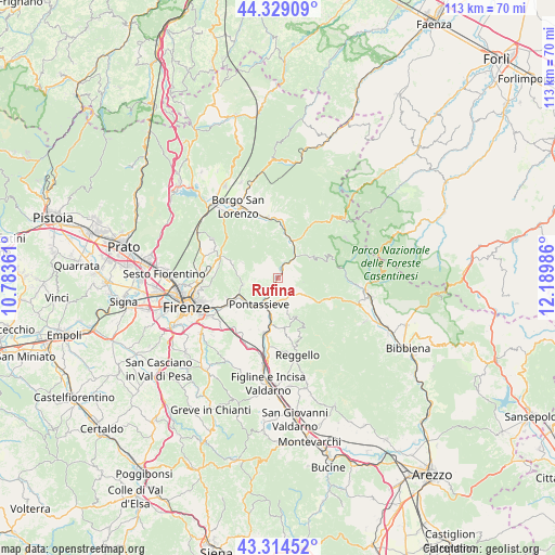
Rufina GPS coordinates[2]
43° 49' 26.256" North, 11° 29' 12.228" East
| Map corner | latitude | longitude |
|---|---|---|
| Upper-left | 44.32909°, | 10.78361° |
| Center: | 43.82396°, | 11.48673° |
| Lower-right: | 43.31452°, | 12.18986° |
| Map W x H: | 112.8×112.8 km | = 70.1×70.1mi |
| max Lat: | 47.04031° ⇑56.7% North |
| Rufina: | 43.82396° |
| min Lat: | ⇓43.3% South 35.50142° |
| min Long | Rufina | max Long |
| 6.69888° | 11.48673° | 18.48682° |
| W 49.2%⇐ | ⇒50.8% E |
Elevation
Elevation of Rufina is 113 m = 371 ft, and this is 193.7 m = 635 ft below average elevation for this country.
| Max E: |
2085 m = 6841 ft | 67.4% |
| Avg. | 306.7 m = 1006 ft | |
| Rufina | 113 m = 371 ft | |
Min E: |
-4 m = -13 ft | 32.6% |
See also: Italy elevation on elevation.city.
Geographical zone
Rufina is located in North temperate zone (between Tropic of Cancer and the Arctic Circle). Distance of this Northern Tropic circle is 2266.8 km =1408.5 mi to South.| Distance of | km | miles | from Rufina |
|---|---|---|---|
| North Pole | 5134.3 | 3190.3 | to North |
| Arctic Circle | 2528.4 | 1571.1 | to North |
| Tropic Cancer | 2266.8 | 1408.5 | to South |
| Equator | 4872.8 | 3027.8 | to South |


Nearby cities:
15 places around Rufina: (largest is in red/bold)
• Diacceto
4.6 km =2.9 mi,  163°
163°
• Dicomano
8.1 km =5 mi,  20°
20°
• Donnini
10.2 km =6.3 mi,  173°
173°
• I filipponi
7.4 km =4.6 mi,  51°
51°
• Londa
7.6 km =4.7 mi, 54°
• Molino del Piano
7.1 km =4.4 mi,  258°
258°
• Montebonello
0.7 km =0.4 mi,  358°
358°
• Pelago
5.8 km =3.6 mi, 168°
• Pontassieve
7.1 km =4.4 mi,  219°
219°
• Rosano
7.9 km =4.9 mi, 220°
• San Francesco
6.3 km =3.9 mi,  209°
209°
• Sandetole
5.9 km =3.7 mi,  38°
38°
• Santa Brigida
7.8 km =4.8 mi,  292°
292°
• Sieci
8.4 km =5.2 mi,  241°
241°
• Tosi
9.1 km =5.7 mi, 156°
Sources, notices
• [Note1] Compared only with cities in Italy existing in our database
• [Src1] Map data: © OpenStreetMap contributors (CC-BY-SA)
• [Src2] Other city data from geonames.org with taken over terms of usage.
• [Src3] Geographical zone / Annual Mean Temperature by Robert A. Rohde @ Wikipedia
