Poderia geodata
Poderia (Campania) is a populated place; located in Italy in Europe/Rome (GMT+2) time zone. With population of 739 people, there are 8029 cities with bigger population in this country. Compared to other cities in Italy, 87.2% of cities are located further ↑North; 90.2% of cities are located further ←West and 60.5% of cities have higher elevation than Poderia. Note1
Administrative division(s):
- Level 1: Campania
- Level 2: Provincia di Salerno
- Level 3: Celle di Bulgheria


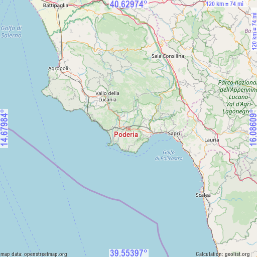
Poderia GPS coordinates[2]
40° 5' 38.328" North, 15° 22' 58.656" East
| Map corner | latitude | longitude |
|---|---|---|
| Upper-left | 40.62974°, | 14.67984° |
| Center: | 40.09398°, | 15.38296° |
| Lower-right: | 39.55397°, | 16.08609° |
| Map W x H: | 119.6×119.6 km | = 74.3×74.3mi |
| max Lat: | 47.04031° ⇑87.2% North |
| Poderia: | 40.09398° |
| min Lat: | ⇓12.8% South 35.50142° |
| min Long | Poderia | max Long |
| 6.69888° | 15.38296° | 18.48682° |
| W 90.2%⇐ | ⇒9.8% E |
Elevation
Elevation of Poderia is 159 m = 522 ft, and this is 147.7 m = 485 ft below average elevation for this country.
| Max E: |
2085 m = 6841 ft | 60.5% |
| Avg. | 306.7 m = 1006 ft | |
| Poderia | 159 m = 522 ft | |
Min E: |
-4 m = -13 ft | 39.5% |
See also: Italy elevation on elevation.city.
Geographical zone
Poderia is located in North temperate zone (between Tropic of Cancer and the Arctic Circle). Distance of this Northern Tropic circle is 1852.1 km =1150.8 mi to South.| Distance of | km | miles | from Poderia |
|---|---|---|---|
| North Pole | 5549 | 3448 | to North |
| Arctic Circle | 2943.1 | 1828.8 | to North |
| Tropic Cancer | 1852.1 | 1150.8 | to South |
| Equator | 4458 | 2770.1 | to South |


Nearby cities:
15 places around Poderia: (largest is in red/bold)
• Acquavena
5.4 km =3.4 mi,  102°
102°
• Camerota
6.9 km =4.3 mi,  188°
188°
• Celle di Bulgheria
1.7 km =1.1 mi,  84°
84°
• Centola
6.6 km =4.1 mi,  246°
246°
• Foria
5.1 km =3.2 mi,  268°
268°
• Futani
8.1 km =5 mi,  321°
321°
• Laurito
8.6 km =5.3 mi,  13°
13°
• Lentiscosa
8 km =5 mi,  180°
180°
• Licusati
4.7 km =2.9 mi,  199°
199°
• Montano Antilia
7.8 km =4.8 mi,  347°
347°
• Roccagloriosa
4.7 km =2.9 mi,  73°
73°
• San Giovanni A Piro
7.2 km =4.5 mi,  131°
131°
• San Mauro la Bruca
8.4 km =5.2 mi,  292°
292°
• Scario
8.5 km =5.3 mi,  114°
114°
• Torre Orsaia
8.8 km =5.5 mi,  60°
60°
Sources, notices
• [Note1] Compared only with cities in Italy existing in our database
• [Src1] Map data: © OpenStreetMap contributors (CC-BY-SA)
• [Src2] Other city data from geonames.org with taken over terms of usage.
• [Src3] Geographical zone / Annual Mean Temperature by Robert A. Rohde @ Wikipedia
