Laurito geodata
Laurito (Campania) is a seat of a third-order administrative division; located in Italy in Europe/Rome (GMT+2) time zone. With population of 744 people, there are 7987 cities with bigger population in this country. Compared to other cities in Italy, 86.6% of cities are located further ↑North; 90.2% of cities are located further ←West and 79.8% of cities have lower elevation than Laurito. Note1


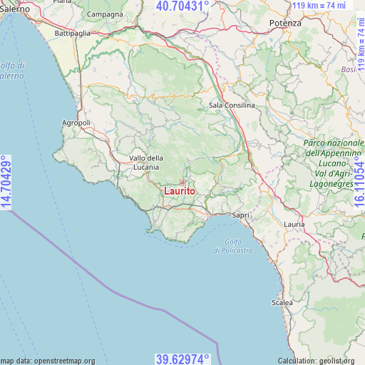
Laurito GPS coordinates[2]
40° 10' 8.94" North, 15° 24' 26.676" East
| Map corner | latitude | longitude |
|---|---|---|
| Upper-left | 40.70431°, | 14.70429° |
| Center: | 40.16915°, | 15.40741° |
| Lower-right: | 39.62974°, | 16.11054° |
| Map W x H: | 119.5×119.5 km | = 74.3×74.3mi |
| max Lat: | 47.04031° ⇑86.6% North |
| Laurito: | 40.16915° |
| min Lat: | ⇓13.4% South 35.50142° |
| min Long | Laurito | max Long |
| 6.69888° | 15.40741° | 18.48682° |
| W 90.2%⇐ | ⇒9.8% E |
Elevation
Elevation of Laurito is 523 m = 1716 ft, and this is 216.3 m = 710 ft above average elevation for this country.
| Max E: |
2085 m = 6841 ft | 20.2% |
| Laurito | 523 m 1716 ft | |
| Avg. | 306.7 m = 1006 ft | |
Min E: |
-4 m = -13 ft | 79.8% |
See also: Italy elevation on elevation.city.
Geographical zone
Laurito is located in North temperate zone (between Tropic of Cancer and the Arctic Circle). Distance of this Northern Tropic circle is 1860.5 km =1156.1 mi to South.| Distance of | km | miles | from Laurito |
|---|---|---|---|
| North Pole | 5540.7 | 3442.8 | to North |
| Arctic Circle | 2934.8 | 1823.6 | to North |
| Tropic Cancer | 1860.5 | 1156.1 | to South |
| Equator | 4466.4 | 2775.3 | to South |


Nearby cities:
15 places around Laurito: (largest is in red/bold)
• Acquavena
10 km =6.2 mi,  161°
161°
• Alfano
1.7 km =1.1 mi,  59°
59°
• Caselle in Pittari
11.5 km =7.1 mi,  87°
87°
• Celle di Bulgheria
8.2 km =5.1 mi,  182°
182°
• Cuccaro Vetere
8.6 km =5.3 mi,  266°
266°
• Foria
11.1 km =6.9 mi,  220°
220°
• Futani
7.4 km =4.6 mi,  254°
254°
• Montano Antilia
3.8 km =2.4 mi,  259°
259°
• Novi Velia
11.9 km =7.4 mi,  299°
299°
• Poderia
8.6 km =5.3 mi,  193°
193°
• Roccagloriosa
7.4 km =4.6 mi, 160°
• Rofrano
5.2 km =3.2 mi,  20°
20°
• San Mauro la Bruca
11.2 km =7 mi,  242°
242°
• Santa Barbara
12.8 km =8 mi, 274°
• Torre Orsaia
6.9 km =4.3 mi,  126°
126°
Sources, notices
• [Note1] Compared only with cities in Italy existing in our database
• [Src1] Map data: © OpenStreetMap contributors (CC-BY-SA)
• [Src2] Other city data from geonames.org with taken over terms of usage.
• [Src3] Geographical zone / Annual Mean Temperature by Robert A. Rohde @ Wikipedia
