Pocenia geodata
Pocenia (Friuli Venezia Giulia) is a seat of a third-order administrative division; located in Italy in Europe/Rome (GMT+2) time zone. With population of 1,451 people, there are 5242 cities with bigger population in this country. Compared to other cities in Italy, 87.3% of cities are located further ↓South; 69.5% of cities are located further ←West and 96.6% of cities have higher elevation than Pocenia. Note1
Administrative division(s):
- Level 1: Friuli Venezia Giulia
- Level 2: Provincia di Udine
- Level 3: Pocenia


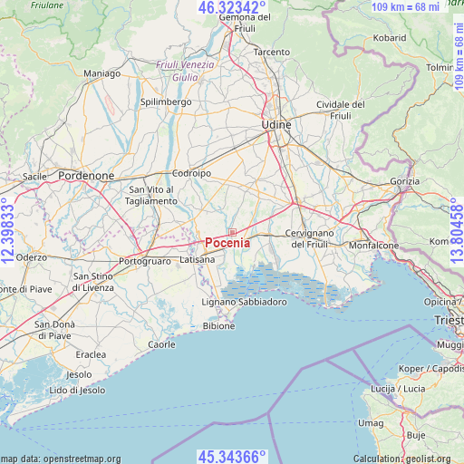
Pocenia GPS coordinates[2]
45° 50' 8.52" North, 13° 6' 5.22" East
| Map corner | latitude | longitude |
|---|---|---|
| Upper-left | 46.32342°, | 12.39833° |
| Center: | 45.8357°, | 13.10145° |
| Lower-right: | 45.34366°, | 13.80458° |
| Map W x H: | 108.9×108.9 km | = 67.7×67.7mi |
| max Lat: | 47.04031° ⇑12.7% North |
| Pocenia: | 45.8357° |
| min Lat: | ⇓87.3% South 35.50142° |
| min Long | Pocenia | max Long |
| 6.69888° | 13.10145° | 18.48682° |
| W 69.5%⇐ | ⇒30.5% E |
Elevation
Elevation of Pocenia is 6 m = 20 ft, and this is 300.7 m = 987 ft below average elevation for this country.
| Max E: |
2085 m = 6841 ft | 96.6% |
| Avg. | 306.7 m = 1006 ft | |
| Pocenia | 6 m = 20 ft | |
Min E: |
-4 m = -13 ft | 3.4% |
See also: Italy elevation on elevation.city.
Geographical zone
Pocenia is located in North temperate zone (between Tropic of Cancer and the Arctic Circle). Distance of this North polar circle is 2304.7 km =1432.1 mi to North.| Distance of | km | miles | from Pocenia |
|---|---|---|---|
| North Pole | 4910.6 | 3051.3 | to North |
| Arctic Circle | 2304.7 | 1432.1 | to North |
| Tropic Cancer | 2490.5 | 1547.5 | to South |
| Equator | 5096.5 | 3166.8 | to South |


Nearby cities:
15 places around Pocenia: (largest is in red/bold)
• Carlino
7.7 km =4.8 mi,  118°
118°
• Casale della Madonna
8.3 km =5.2 mi,  142°
142°
• Marano Lagunare
9.5 km =5.9 mi,  147°
147°
• Muzzana del Turgnano
2.8 km =1.7 mi,  134°
134°
• Palazzolo dello Stella
4.3 km =2.7 mi,  194°
194°
• Porpetto
9.3 km =5.8 mi,  75°
75°
• Precenicco
4.8 km =3 mi,  204°
204°
• Rivarotta
2.2 km =1.4 mi,  224°
224°
• Rivignano
6.4 km =4 mi,  313°
313°
• Romans
9.5 km =5.9 mi,  318°
318°
• Ronchis
8.8 km =5.5 mi,  249°
249°
• San Giorgio di Nogaro
8.5 km =5.3 mi,  96°
96°
• Teor
4.1 km =2.5 mi,  300°
300°
• Torsa
4.4 km =2.7 mi,  15°
15°
• Varmo
10.3 km =6.4 mi, 303°
Sources, notices
• [Note1] Compared only with cities in Italy existing in our database
• [Src1] Map data: © OpenStreetMap contributors (CC-BY-SA)
• [Src2] Other city data from geonames.org with taken over terms of usage.
• [Src3] Geographical zone / Annual Mean Temperature by Robert A. Rohde @ Wikipedia
