Ronchis geodata
Ronchis (Friuli Venezia Giulia) is a seat of a third-order administrative division; located in Italy in Europe/Rome (GMT+2) time zone. With population of 1,643 people, there are 4800 cities with bigger population in this country. Compared to other cities in Italy, 86.1% of cities are located further ↓South; 68.2% of cities are located further ←West and 95.3% of cities have higher elevation than Ronchis. Note1
Administrative division(s):
- Level 1: Friuli Venezia Giulia
- Level 2: Provincia di Udine
- Level 3: Ronchis


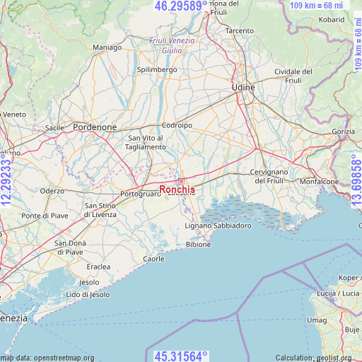
Ronchis GPS coordinates[2]
45° 48' 28.512" North, 12° 59' 43.62" East
| Map corner | latitude | longitude |
|---|---|---|
| Upper-left | 46.29589°, | 12.29233° |
| Center: | 45.80792°, | 12.99545° |
| Lower-right: | 45.31564°, | 13.69858° |
| Map W x H: | 109×109 km | = 67.7×67.7mi |
| max Lat: | 47.04031° ⇑13.9% North |
| Ronchis: | 45.80792° |
| min Lat: | ⇓86.1% South 35.50142° |
| min Long | Ronchis | max Long |
| 6.69888° | 12.99545° | 18.48682° |
| W 68.2%⇐ | ⇒31.8% E |
Elevation
Elevation of Ronchis is 8 m = 26 ft, and this is 298.7 m = 980 ft below average elevation for this country.
| Max E: |
2085 m = 6841 ft | 95.3% |
| Avg. | 306.7 m = 1006 ft | |
| Ronchis | 8 m = 26 ft | |
Min E: |
-4 m = -13 ft | 4.7% |
See also: Italy elevation on elevation.city.
Geographical zone
Ronchis is located in North temperate zone (between Tropic of Cancer and the Arctic Circle). Distance of this North polar circle is 2307.8 km =1434 mi to North.| Distance of | km | miles | from Ronchis |
|---|---|---|---|
| North Pole | 4913.7 | 3053.2 | to North |
| Arctic Circle | 2307.8 | 1434 | to North |
| Tropic Cancer | 2487.4 | 1545.6 | to South |
| Equator | 5093.4 | 3164.9 | to South |


Nearby cities:
15 places around Ronchis: (largest is in red/bold)
• Fossalta di Portogruaro
6.8 km =4.2 mi,  256°
256°
• Gorgo
7.1 km =4.4 mi,  161°
161°
• Latisana
4.5 km =2.8 mi,  169°
169°
• Lugugnana
8.8 km =5.5 mi,  198°
198°
• Morsano
7.8 km =4.8 mi,  317°
317°
• Palazzolo dello Stella
7.2 km =4.5 mi,  98°
98°
• Pocenia
8.8 km =5.5 mi,  69°
69°
• Precenicco
6.3 km =3.9 mi, 101°
• Rivarotta
6.8 km =4.2 mi,  77°
77°
• Rivignano
8.4 km =5.2 mi,  25°
25°
• San Giorgio al Tagliamento-Pozzi
2.8 km =1.7 mi,  242°
242°
• San Michele al Tagliamento
4.8 km =3 mi,  180°
180°
• Teglio Veneto
8.7 km =5.4 mi,  276°
276°
• Teor
7 km =4.3 mi,  42°
42°
• Varmo
8.7 km =5.4 mi,  357°
357°
Sources, notices
• [Note1] Compared only with cities in Italy existing in our database
• [Src1] Map data: © OpenStreetMap contributors (CC-BY-SA)
• [Src2] Other city data from geonames.org with taken over terms of usage.
• [Src3] Geographical zone / Annual Mean Temperature by Robert A. Rohde @ Wikipedia
