Piedicavallo geodata
Piedicavallo (Piedmont) is a seat of a third-order administrative division; located in Italy in Europe/Rome (GMT+2) time zone. With population of 124 people, there are 11370 cities with bigger population in this country. Compared to other cities in Italy, 80.8% of cities are located further ↓South; 94.1% of cities are located further →East and 97.7% of cities have lower elevation than Piedicavallo. Note1


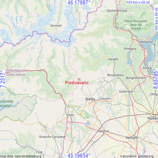
Piedicavallo GPS coordinates[2]
45° 41' 23.496" North, 7° 57' 17.352" East
| Map corner | latitude | longitude |
|---|---|---|
| Upper-left | 46.17887°, | 7.2517° |
| Center: | 45.68986°, | 7.95482° |
| Lower-right: | 45.19654°, | 8.65795° |
| Map W x H: | 109.2×109.2 km | = 67.9×67.9mi |
| max Lat: | 47.04031° ⇑19.2% North |
| Piedicavallo: | 45.68986° |
| min Lat: | ⇓80.8% South 35.50142° |
| min Long | Piedicavallo | max Long |
| 6.69888° | 7.95482° | 18.48682° |
| W 5.9%⇐ | ⇒94.1% E |
Elevation
Elevation of Piedicavallo is 1064 m = 3491 ft, and this is 757.3 m = 2485 ft above average elevation for this country.
| Max E: |
2085 m = 6841 ft | 2.3% |
| Piedicavallo | 1064 m 3491 ft | |
| Avg. | 306.7 m = 1006 ft | |
Min E: |
-4 m = -13 ft | 97.7% |
See also: Italy elevation on elevation.city.
Geographical zone
Piedicavallo is located in North temperate zone (between Tropic of Cancer and the Arctic Circle). Distance of this North polar circle is 2320.9 km =1442.1 mi to North.| Distance of | km | miles | from Piedicavallo |
|---|---|---|---|
| North Pole | 4926.8 | 3061.4 | to North |
| Arctic Circle | 2320.9 | 1442.1 | to North |
| Tropic Cancer | 2474.3 | 1537.5 | to South |
| Equator | 5080.2 | 3156.7 | to South |


Nearby cities:
15 places around Piedicavallo: (largest is in red/bold)
• Andorno Cacciorna
11.8 km =7.3 mi,  138°
138°
• Callabiana - Chiesa
12.8 km =8 mi,  120°
120°
• Camandona
12.4 km =7.7 mi,  114°
114°
• Campiglia Cervo
4.6 km =2.9 mi,  130°
130°
• Fontainemore
8.8 km =5.5 mi,  237°
237°
• Gaby
6.2 km =3.9 mi,  294°
294°
• Issime
7.8 km =4.8 mi,  266°
266°
• Lillianes
11.1 km =6.9 mi,  232°
232°
• Miagliano
11 km =6.8 mi, 140°
• Piode
11.8 km =7.3 mi,  40°
40°
• Rassa
9.8 km =6.1 mi,  27°
27°
• Rosazza
2.3 km =1.4 mi, 132°
• Sagliano Micca
9.9 km =6.2 mi, 136°
• Selve Marcone
12.9 km =8 mi, 127°
• Tavigliano
10.7 km =6.6 mi, 135°
Sources, notices
• [Note1] Compared only with cities in Italy existing in our database
• [Src1] Map data: © OpenStreetMap contributors (CC-BY-SA)
• [Src2] Other city data from geonames.org with taken over terms of usage.
• [Src3] Geographical zone / Annual Mean Temperature by Robert A. Rohde @ Wikipedia
