Rassa geodata
Rassa (Piedmont) is a seat of a third-order administrative division; located in Italy in Europe/Rome (GMT+2) time zone. With population of 59 people, there are 11579 cities with bigger population in this country. Compared to other cities in Italy, 84.4% of cities are located further ↓South; 93.4% of cities are located further →East and 96.2% of cities have lower elevation than Rassa. Note1


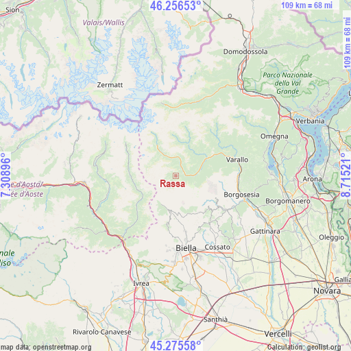
Rassa GPS coordinates[2]
45° 46' 5.556" North, 8° 0' 43.488" East
| Map corner | latitude | longitude |
|---|---|---|
| Upper-left | 46.25653°, | 7.30896° |
| Center: | 45.76821°, | 8.01208° |
| Lower-right: | 45.27558°, | 8.71521° |
| Map W x H: | 109.1×109.1 km | = 67.8×67.8mi |
| max Lat: | 47.04031° ⇑15.6% North |
| Rassa: | 45.76821° |
| min Lat: | ⇓84.4% South 35.50142° |
| min Long | Rassa | max Long |
| 6.69888° | 8.01208° | 18.48682° |
| W 6.6%⇐ | ⇒93.4% E |
Elevation
Elevation of Rassa is 945 m = 3100 ft, and this is 638.3 m = 2094 ft above average elevation for this country.
| Max E: |
2085 m = 6841 ft | 3.8% |
| Rassa | 945 m 3100 ft | |
| Avg. | 306.7 m = 1006 ft | |
Min E: |
-4 m = -13 ft | 96.2% |
See also: Italy elevation on elevation.city.
Geographical zone
Rassa is located in North temperate zone (between Tropic of Cancer and the Arctic Circle). Distance of this North polar circle is 2312.2 km =1436.7 mi to North.| Distance of | km | miles | from Rassa |
|---|---|---|---|
| North Pole | 4918.1 | 3056 | to North |
| Arctic Circle | 2312.2 | 1436.7 | to North |
| Tropic Cancer | 2483 | 1542.9 | to South |
| Equator | 5088.9 | 3162.1 | to South |


Nearby cities:
15 places around Rassa: (largest is in red/bold)
• Alagna Valsesia
10.9 km =6.8 mi,  328°
328°
• Balmuccia
11.5 km =7.1 mi,  60°
60°
• Boccioleto
10.4 km =6.5 mi,  48°
48°
• Campertogno
3.7 km =2.3 mi,  24°
24°
• Campiglia Cervo
11.7 km =7.3 mi,  184°
184°
• Mollia
5.6 km =3.5 mi,  14°
14°
• Piedicavallo
9.8 km =6.1 mi,  207°
207°
• Pila
5.4 km =3.4 mi,  87°
87°
• Piode
3.2 km =2 mi, 85°
• Rimasco
11 km =6.8 mi, 21°
• Riva Valdobbia
8.2 km =5.1 mi, 328°
• Rosazza
10.6 km =6.6 mi,  194°
194°
• Rossa
11.3 km =7 mi, 50°
• Scopa
8.4 km =5.2 mi,  70°
70°
• Scopello
6.4 km =4 mi,  84°
84°
Sources, notices
• [Note1] Compared only with cities in Italy existing in our database
• [Src1] Map data: © OpenStreetMap contributors (CC-BY-SA)
• [Src2] Other city data from geonames.org with taken over terms of usage.
• [Src3] Geographical zone / Annual Mean Temperature by Robert A. Rohde @ Wikipedia
