Lignana geodata
Lignana (Piedmont) is a seat of a third-order administrative division; located in Italy in Europe/Rome (GMT+2) time zone. With population of 519 people, there are 9740 cities with bigger population in this country. Compared to other cities in Italy, 67.1% of cities are located further ↓South; 89.6% of cities are located further →East and 63.5% of cities have higher elevation than Lignana. Note1


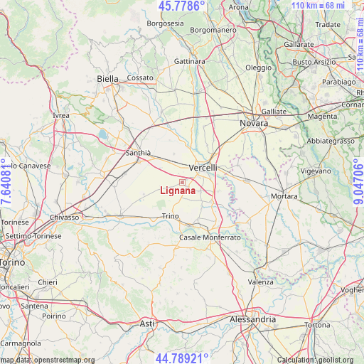
Lignana GPS coordinates[2]
45° 17' 9.816" North, 8° 20' 38.148" East
| Map corner | latitude | longitude |
|---|---|---|
| Upper-left | 45.7786°, | 7.64081° |
| Center: | 45.28606°, | 8.34393° |
| Lower-right: | 44.78921°, | 9.04706° |
| Map W x H: | 110×110 km | = 68.4×68.4mi |
| max Lat: | 47.04031° ⇑32.9% North |
| Lignana: | 45.28606° |
| min Lat: | ⇓67.1% South 35.50142° |
| min Long | Lignana | max Long |
| 6.69888° | 8.34393° | 18.48682° |
| W 10.4%⇐ | ⇒89.6% E |
Elevation
Elevation of Lignana is 137 m = 449 ft, and this is 169.7 m = 557 ft below average elevation for this country.
| Max E: |
2085 m = 6841 ft | 63.5% |
| Avg. | 306.7 m = 1006 ft | |
| Lignana | 137 m = 449 ft | |
Min E: |
-4 m = -13 ft | 36.5% |
See also: Italy elevation on elevation.city.
Geographical zone
Lignana is located in North temperate zone (between Tropic of Cancer and the Arctic Circle). Distance of this North polar circle is 2365.8 km =1470 mi to North.| Distance of | km | miles | from Lignana |
|---|---|---|---|
| North Pole | 4971.7 | 3089.3 | to North |
| Arctic Circle | 2365.8 | 1470 | to North |
| Tropic Cancer | 2429.4 | 1509.6 | to South |
| Equator | 5035.3 | 3128.8 | to South |


Nearby cities:
15 places around Lignana: (largest is in red/bold)
• Asigliano Vercellese
5.7 km =3.5 mi,  118°
118°
• Caresanablot
8.8 km =5.5 mi,  25°
25°
• Costanzana
5.8 km =3.6 mi,  159°
159°
• Desana
2.2 km =1.4 mi,  150°
150°
• Olcenengo
9 km =5.6 mi,  342°
342°
• Pertengo
7.9 km =4.9 mi,  134°
134°
• Prarolo
10.5 km =6.5 mi,  92°
92°
• Quinto Vercellese
10.5 km =6.5 mi,  7°
7°
• Rive
9.9 km =6.2 mi,  144°
144°
• Ronsecco
6.4 km =4 mi,  234°
234°
• Salasco
7.6 km =4.7 mi,  305°
305°
• Sali Vercellese
2.9 km =1.8 mi, 336°
• San Germano Vercellese
10.5 km =6.5 mi, 313°
• Tricerro
5.7 km =3.5 mi,  192°
192°
• Vercelli
7.1 km =4.4 mi,  56°
56°
Sources, notices
• [Note1] Compared only with cities in Italy existing in our database
• [Src1] Map data: © OpenStreetMap contributors (CC-BY-SA)
• [Src2] Other city data from geonames.org with taken over terms of usage.
• [Src3] Geographical zone / Annual Mean Temperature by Robert A. Rohde @ Wikipedia
