Patrica geodata
Patrica (Latium) is a seat of a third-order administrative division; located in Italy in Europe/Rome (GMT+2) time zone. With population of 471 people, there are 10018 cities with bigger population in this country. Compared to other cities in Italy, 74% of cities are located further ↑North; 70.8% of cities are located further ←West and 71.1% of cities have lower elevation than Patrica. Note1


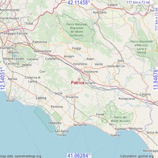
Patrica GPS coordinates[2]
41° 35' 27.06" North, 13° 14' 37.068" East
| Map corner | latitude | longitude |
|---|---|---|
| Upper-left | 42.11458°, | 12.54051° |
| Center: | 41.59085°, | 13.24363° |
| Lower-right: | 41.06284°, | 13.94676° |
| Map W x H: | 116.9×116.9 km | = 72.6×72.6mi |
| max Lat: | 47.04031° ⇑74% North |
| Patrica: | 41.59085° |
| min Lat: | ⇓26% South 35.50142° |
| min Long | Patrica | max Long |
| 6.69888° | 13.24363° | 18.48682° |
| W 70.8%⇐ | ⇒29.2% E |
Elevation
Elevation of Patrica is 404 m = 1325 ft, and this is 97.3 m = 319 ft above average elevation for this country.
| Max E: |
2085 m = 6841 ft | 28.9% |
| Patrica | 404 m 1325 ft | |
| Avg. | 306.7 m = 1006 ft | |
Min E: |
-4 m = -13 ft | 71.1% |
See also: Italy elevation on elevation.city.
Geographical zone
Patrica is located in North temperate zone (between Tropic of Cancer and the Arctic Circle). Distance of this Northern Tropic circle is 2018.6 km =1254.3 mi to South.| Distance of | km | miles | from Patrica |
|---|---|---|---|
| North Pole | 5382.6 | 3344.6 | to North |
| Arctic Circle | 2776.7 | 1725.4 | to North |
| Tropic Cancer | 2018.6 | 1254.3 | to South |
| Equator | 4624.5 | 2873.5 | to South |


Nearby cities:
15 places around Patrica: (largest is in red/bold)
• Cartiera-Stazione
7.3 km =4.5 mi,  358°
358°
• Ceccano
7.4 km =4.6 mi,  106°
106°
• Cerquotti-Madonna del Piano
6.2 km =3.9 mi,  335°
335°
• Farneta
10 km =6.2 mi, 108°
• Fresine
8.6 km =5.3 mi,  5°
5°
• Frosinone
9.8 km =6.1 mi,  56°
56°
• Giuliano di Roma
6.5 km =4 mi,  151°
151°
• Maenza
9 km =5.6 mi,  213°
213°
• Morolo
6.5 km =4 mi,  324°
324°
• Pantano Cosa
6.3 km =3.9 mi,  88°
88°
• Prossedi
8.4 km =5.2 mi,  170°
170°
• Quattro Strade
3.6 km =2.2 mi, 86°
• Roccagorga
10.4 km =6.5 mi,  225°
225°
• Supino
3.5 km =2.2 mi,  347°
347°
• Villa Santo Stefano
9.9 km =6.2 mi, 145°
Sources, notices
• [Note1] Compared only with cities in Italy existing in our database
• [Src1] Map data: © OpenStreetMap contributors (CC-BY-SA)
• [Src2] Other city data from geonames.org with taken over terms of usage.
• [Src3] Geographical zone / Annual Mean Temperature by Robert A. Rohde @ Wikipedia
