Morolo geodata
Morolo (Latium) is a seat of a third-order administrative division; located in Italy in Europe/Rome (GMT+2) time zone. With population of 634 people, there are 8749 cities with bigger population in this country. Compared to other cities in Italy, 73.6% of cities are located further ↑North; 70.4% of cities are located further ←West and 67.3% of cities have lower elevation than Morolo. Note1


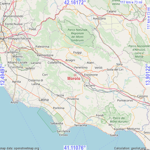
Morolo GPS coordinates[2]
41° 38' 18.168" North, 13° 11' 53.124" East
| Map corner | latitude | longitude |
|---|---|---|
| Upper-left | 42.16172°, | 12.49497° |
| Center: | 41.63838°, | 13.19809° |
| Lower-right: | 41.11076°, | 13.90122° |
| Map W x H: | 116.9×116.9 km | = 72.6×72.6mi |
| max Lat: | 47.04031° ⇑73.6% North |
| Morolo: | 41.63838° |
| min Lat: | ⇓26.4% South 35.50142° |
| min Long | Morolo | max Long |
| 6.69888° | 13.19809° | 18.48682° |
| W 70.4%⇐ | ⇒29.6% E |
Elevation
Elevation of Morolo is 366 m = 1201 ft, and this is 59.3 m = 195 ft above average elevation for this country.
| Max E: |
2085 m = 6841 ft | 32.7% |
| Morolo | 366 m 1201 ft | |
| Avg. | 306.7 m = 1006 ft | |
Min E: |
-4 m = -13 ft | 67.3% |
See also: Italy elevation on elevation.city.
Geographical zone
Morolo is located in North temperate zone (between Tropic of Cancer and the Arctic Circle). Distance of this Northern Tropic circle is 2023.8 km =1257.5 mi to South.| Distance of | km | miles | from Morolo |
|---|---|---|---|
| North Pole | 5377.3 | 3341.3 | to North |
| Arctic Circle | 2771.4 | 1722.1 | to North |
| Tropic Cancer | 2023.8 | 1257.5 | to South |
| Equator | 4629.8 | 2876.8 | to South |


Nearby cities:
15 places around Morolo: (largest is in red/bold)
• Carpineto Romano
10.2 km =6.3 mi,  248°
248°
• Cartiera-Stazione
4.1 km =2.5 mi,  60°
60°
• Cerquotti-Madonna del Piano
1.3 km =0.8 mi,  72°
72°
• Ferentino
7.6 km =4.7 mi,  39°
39°
• Fresine
5.7 km =3.5 mi, 55°
• Gorga
7.8 km =4.8 mi,  283°
283°
• Madonna delle Grazie Iacp
11.2 km =7 mi,  340°
340°
• Osteria della Fontana
11 km =6.8 mi, 335°
• Pantano Cosa
11.3 km =7 mi,  116°
116°
• Patrica
6.5 km =4 mi,  144°
144°
• Quattro Strade
8.9 km =5.5 mi, 124°
• Sgurgola
5.2 km =3.2 mi,  310°
310°
• Supino
3.6 km =2.2 mi, 122°
• Tofe
5.5 km =3.4 mi,  20°
20°
• Tufano
10.3 km =6.4 mi,  3°
3°
Sources, notices
• [Note1] Compared only with cities in Italy existing in our database
• [Src1] Map data: © OpenStreetMap contributors (CC-BY-SA)
• [Src2] Other city data from geonames.org with taken over terms of usage.
• [Src3] Geographical zone / Annual Mean Temperature by Robert A. Rohde @ Wikipedia
