Cartiera-Stazione geodata
Cartiera-Stazione (Latium) is a populated place; located in Italy in Europe/Rome (GMT+2) time zone. With population of 1,145 people, there are 6129 cities with bigger population in this country. Compared to other cities in Italy, 73.4% of cities are located further ↑North; 70.7% of cities are located further ←West and 61.5% of cities have higher elevation than Cartiera-Stazione. Note1


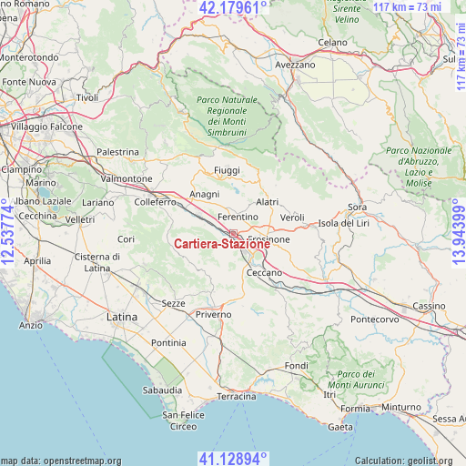
Cartiera-Stazione GPS coordinates[2]
41° 39' 23.112" North, 13° 14' 27.096" East
| Map corner | latitude | longitude |
|---|---|---|
| Upper-left | 42.17961°, | 12.53774° |
| Center: | 41.65642°, | 13.24086° |
| Lower-right: | 41.12894°, | 13.94399° |
| Map W x H: | 116.8×116.8 km | = 72.6×72.6mi |
| max Lat: | 47.04031° ⇑73.4% North |
| Cartiera-Stazione: | 41.65642° |
| min Lat: | ⇓26.6% South 35.50142° |
| min Long | Cartiera-Stazio | max Long |
| 6.69888° | 13.24086° | 18.48682° |
| W 70.7%⇐ | ⇒29.3% E |
Elevation
Elevation of Cartiera-Stazione is 152 m = 499 ft, and this is 154.7 m = 508 ft below average elevation for this country.
| Max E: |
2085 m = 6841 ft | 61.5% |
| Avg. | 306.7 m = 1006 ft | |
| Cartiera-Stazione | 152 m = 499 ft | |
Min E: |
-4 m = -13 ft | 38.5% |
See also: Italy elevation on elevation.city.
Geographical zone
Cartiera-Stazione is located in North temperate zone (between Tropic of Cancer and the Arctic Circle). Distance of this Northern Tropic circle is 2025.8 km =1258.8 mi to South.| Distance of | km | miles | from Cartiera-Stazione |
|---|---|---|---|
| North Pole | 5375.3 | 3340.1 | to North |
| Arctic Circle | 2769.4 | 1720.8 | to North |
| Tropic Cancer | 2025.8 | 1258.8 | to South |
| Equator | 4631.8 | 2878.1 | to South |


Nearby cities:
15 places around Cartiera-Stazione: (largest is in red/bold)
• Arillette
9.1 km =5.7 mi,  82°
82°
• Cerquotti-Madonna del Piano
2.8 km =1.7 mi,  235°
235°
• Ferentino
4.1 km =2.5 mi,  18°
18°
• Fresine
1.7 km =1.1 mi,  41°
41°
• Frosinone
8.5 km =5.3 mi,  102°
102°
• Fumone
9 km =5.6 mi, 15°
• Monte San Marino
8.5 km =5.3 mi, 43°
• Morolo
4.1 km =2.5 mi, 240°
• Patrica
7.3 km =4.5 mi,  178°
178°
• Quattro Strade
8 km =5 mi,  151°
151°
• Sgurgola
7.7 km =4.8 mi,  280°
280°
• Supino
3.9 km =2.4 mi,  187°
187°
• Tecchiena
9.4 km =5.8 mi,  67°
67°
• Tofe
3.5 km =2.2 mi,  332°
332°
• Tufano
8.7 km =5.4 mi,  340°
340°
Sources, notices
• [Note1] Compared only with cities in Italy existing in our database
• [Src1] Map data: © OpenStreetMap contributors (CC-BY-SA)
• [Src2] Other city data from geonames.org with taken over terms of usage.
• [Src3] Geographical zone / Annual Mean Temperature by Robert A. Rohde @ Wikipedia
