Palù geodata
Palù (Veneto) is a seat of a third-order administrative division; located in Italy in Europe/Rome (GMT+2) time zone. With population of 912 people, there are 7083 cities with bigger population in this country. Compared to other cities in Italy, 68.1% of cities are located further ↓South; 55% of cities are located further →East and 87.4% of cities have higher elevation than Palù. Note1


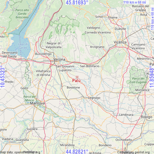
Palù GPS coordinates[2]
45° 19' 29.028" North, 11° 9' 22.86" East
| Map corner | latitude | longitude |
|---|---|---|
| Upper-left | 45.81693°, | 10.45323° |
| Center: | 45.32473°, | 11.15635° |
| Lower-right: | 44.82821°, | 11.85948° |
| Map W x H: | 109.9×109.9 km | = 68.3×68.3mi |
| max Lat: | 47.04031° ⇑31.9% North |
| Palù: | 45.32473° |
| min Lat: | ⇓68.1% South 35.50142° |
| min Long | Palù | max Long |
| 6.69888° | 11.15635° | 18.48682° |
| W 45%⇐ | ⇒55% E |
Elevation
Elevation of Palù is 24 m = 79 ft, and this is 282.7 m = 927 ft below average elevation for this country.
| Max E: |
2085 m = 6841 ft | 87.4% |
| Avg. | 306.7 m = 1006 ft | |
| Palù | 24 m = 79 ft | |
Min E: |
-4 m = -13 ft | 12.6% |
See also: Italy elevation on elevation.city.
Geographical zone
Palù is located in North temperate zone (between Tropic of Cancer and the Arctic Circle). Distance of this North polar circle is 2361.5 km =1467.4 mi to North.| Distance of | km | miles | from Palù |
|---|---|---|---|
| North Pole | 4967.4 | 3086.6 | to North |
| Arctic Circle | 2361.5 | 1467.4 | to North |
| Tropic Cancer | 2433.7 | 1512.2 | to South |
| Equator | 5039.6 | 3131.5 | to South |


Nearby cities:
15 places around Palù: (largest is in red/bold)
• Albaro
4.2 km =2.6 mi,  41°
41°
• Belfiore
7.7 km =4.8 mi,  33°
33°
• Bonavicina
9.2 km =5.7 mi,  166°
166°
• Bovolone
7.7 km =4.8 mi,  203°
203°
• Ca' degli Oppi
3.8 km =2.4 mi,  212°
212°
• Campagnola
9.1 km =5.7 mi,  294°
294°
• Isola Rizza
4.9 km =3 mi,  137°
137°
• Oppeano
3 km =1.9 mi, 142°
• Perzacco
4.9 km =3 mi, 28°
• Ronco All'Adige
6.4 km =4 mi,  78°
78°
• Roverchiara
9.4 km =5.8 mi,  132°
132°
• Tombazosana
7.9 km =4.9 mi,  98°
98°
• Vallese
5.5 km =3.4 mi,  274°
274°
• Villafontana
6.6 km =4.1 mi,  237°
237°
• Zevio
5.7 km =3.5 mi,  338°
338°
Sources, notices
• [Note1] Compared only with cities in Italy existing in our database
• [Src1] Map data: © OpenStreetMap contributors (CC-BY-SA)
• [Src2] Other city data from geonames.org with taken over terms of usage.
• [Src3] Geographical zone / Annual Mean Temperature by Robert A. Rohde @ Wikipedia
