Albaro geodata
Albaro (Veneto) is a populated place; located in Italy in Europe/Rome (GMT+2) time zone. With population of 764 people, there are 7855 cities with bigger population in this country. Compared to other cities in Italy, 68.9% of cities are located further ↓South; 54.5% of cities are located further →East and 87.4% of cities have higher elevation than Albaro. Note1


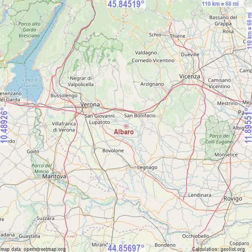
Albaro GPS coordinates[2]
45° 21' 11.664" North, 11° 11' 32.568" East
| Map corner | latitude | longitude |
|---|---|---|
| Upper-left | 45.84519°, | 10.48926° |
| Center: | 45.35324°, | 11.19238° |
| Lower-right: | 44.85697°, | 11.89551° |
| Map W x H: | 109.9×109.9 km | = 68.3×68.3mi |
| max Lat: | 47.04031° ⇑31.1% North |
| Albaro: | 45.35324° |
| min Lat: | ⇓68.9% South 35.50142° |
| min Long | Albaro | max Long |
| 6.69888° | 11.19238° | 18.48682° |
| W 45.5%⇐ | ⇒54.5% E |
Elevation
Elevation of Albaro is 24 m = 79 ft, and this is 282.7 m = 927 ft below average elevation for this country.
| Max E: |
2085 m = 6841 ft | 87.4% |
| Avg. | 306.7 m = 1006 ft | |
| Albaro | 24 m = 79 ft | |
Min E: |
-4 m = -13 ft | 12.6% |
See also: Italy elevation on elevation.city.
Geographical zone
Albaro is located in North temperate zone (between Tropic of Cancer and the Arctic Circle). Distance of this North polar circle is 2358.4 km =1465.4 mi to North.| Distance of | km | miles | from Albaro |
|---|---|---|---|
| North Pole | 4964.3 | 3084.7 | to North |
| Arctic Circle | 2358.4 | 1465.4 | to North |
| Tropic Cancer | 2436.9 | 1514.2 | to South |
| Equator | 5042.8 | 3133.4 | to South |


Nearby cities:
15 places around Albaro: (largest is in red/bold)
• Albaredo d'Adige
7.8 km =4.8 mi,  119°
119°
• Arcole
7.5 km =4.7 mi,  83°
83°
• Belfiore
3.5 km =2.2 mi,  24°
24°
• Ca' degli Oppi
8 km =5 mi,  217°
217°
• Caldierino-Rota
7.5 km =4.7 mi,  338°
338°
• Caldiero
6.9 km =4.3 mi,  350°
350°
• Isola Rizza
6.8 km =4.2 mi,  175°
175°
• Oppeano
5.6 km =3.5 mi,  189°
189°
• Palù
4.2 km =2.6 mi, 221°
• Perzacco
1.3 km =0.8 mi, 336°
• Ronco All'Adige
3.9 km =2.4 mi, 118°
• San Bonifacio
7.9 km =4.9 mi,  53°
53°
• Tombazosana
6.6 km =4.1 mi,  130°
130°
• Villabella
6.9 km =4.3 mi,  36°
36°
• Zevio
5.4 km =3.4 mi,  293°
293°
Sources, notices
• [Note1] Compared only with cities in Italy existing in our database
• [Src1] Map data: © OpenStreetMap contributors (CC-BY-SA)
• [Src2] Other city data from geonames.org with taken over terms of usage.
• [Src3] Geographical zone / Annual Mean Temperature by Robert A. Rohde @ Wikipedia
