Paesana geodata
Paesana (Piedmont) is a seat of a third-order administrative division; located in Italy in Europe/Rome (GMT+2) time zone. With population of 1,895 people, there are 4325 cities with bigger population in this country. Compared to other cities in Italy, 53.9% of cities are located further ↓South; 99.1% of cities are located further →East and 84.9% of cities have lower elevation than Paesana. Note1


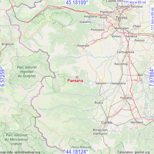
Paesana GPS coordinates[2]
44° 40' 59.952" North, 7° 16' 32.556" East
| Map corner | latitude | longitude |
|---|---|---|
| Upper-left | 45.18109°, | 6.57259° |
| Center: | 44.68332°, | 7.27571° |
| Lower-right: | 44.18124°, | 7.97884° |
| Map W x H: | 111.2×111.2 km | = 69.1×69.1mi |
| max Lat: | 47.04031° ⇑46.1% North |
| Paesana: | 44.68332° |
| min Lat: | ⇓53.9% South 35.50142° |
| min Long | Paesana | max Long |
| 6.69888° | 7.27571° | 18.48682° |
| W 0.9%⇐ | ⇒99.1% E |
Elevation
Elevation of Paesana is 608 m = 1995 ft, and this is 301.3 m = 989 ft above average elevation for this country.
| Max E: |
2085 m = 6841 ft | 15.1% |
| Paesana | 608 m 1995 ft | |
| Avg. | 306.7 m = 1006 ft | |
Min E: |
-4 m = -13 ft | 84.9% |
See also: Italy elevation on elevation.city.
Geographical zone
Paesana is located in North temperate zone (between Tropic of Cancer and the Arctic Circle). Distance of this Northern Tropic circle is 2362.4 km =1467.9 mi to South.| Distance of | km | miles | from Paesana |
|---|---|---|---|
| North Pole | 5038.7 | 3130.9 | to North |
| Arctic Circle | 2432.9 | 1511.7 | to North |
| Tropic Cancer | 2362.4 | 1467.9 | to South |
| Equator | 4968.3 | 3087.2 | to South |


Nearby cities:
15 places around Paesana: (largest is in red/bold)
• Bagnolo Piemonte
9.1 km =5.7 mi,  19°
19°
• Barge
6.2 km =3.9 mi,  36°
36°
• Bibiana
12.9 km =8 mi,  4°
4°
• Crissolo
9.6 km =6 mi,  280°
280°
• Envie
7.6 km =4.7 mi,  91°
91°
• Frassino
12.4 km =7.7 mi,  180°
180°
• Gambasca
8.2 km =5.1 mi,  136°
136°
• Isasca
13.5 km =8.4 mi, 141°
• Martiniana Po
9.3 km =5.8 mi,  132°
132°
• Oncino
6.8 km =4.2 mi,  263°
263°
• Ostana
6.9 km =4.3 mi, 278°
• Revello
9.6 km =6 mi,  109°
109°
• Rifreddo
6.7 km =4.2 mi,  122°
122°
• Sampeyre
13.5 km =8.4 mi,  210°
210°
• Sanfront
5.5 km =3.4 mi, 137°
Sources, notices
• [Note1] Compared only with cities in Italy existing in our database
• [Src1] Map data: © OpenStreetMap contributors (CC-BY-SA)
• [Src2] Other city data from geonames.org with taken over terms of usage.
• [Src3] Geographical zone / Annual Mean Temperature by Robert A. Rohde @ Wikipedia
