Ozieri geodata
Ozieri (Sardinia) is a seat of a third-order administrative division; located in Italy in Europe/Rome (GMT+2) time zone. With population of 7,764 people, there are 1255 cities with bigger population in this country. Compared to other cities in Italy, 83.5% of cities are located further ↑North; 81.2% of cities are located further →East and 68.6% of cities have lower elevation than Ozieri. Note1


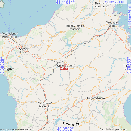
Ozieri GPS coordinates[2]
40° 35' 10.68" North, 9° 0' 12.24" East
| Map corner | latitude | longitude |
|---|---|---|
| Upper-left | 41.11814°, | 8.30028° |
| Center: | 40.5863°, | 9.0034° |
| Lower-right: | 40.0502°, | 9.70653° |
| Map W x H: | 118.7×118.7 km | = 73.8×73.8mi |
| max Lat: | 47.04031° ⇑83.5% North |
| Ozieri: | 40.5863° |
| min Lat: | ⇓16.5% South 35.50142° |
| min Long | Ozieri | max Long |
| 6.69888° | 9.0034° | 18.48682° |
| W 18.8%⇐ | ⇒81.2% E |
Elevation
Elevation of Ozieri is 380 m = 1247 ft, and this is 73.3 m = 240 ft above average elevation for this country.
| Max E: |
2085 m = 6841 ft | 31.4% |
| Ozieri | 380 m 1247 ft | |
| Avg. | 306.7 m = 1006 ft | |
Min E: |
-4 m = -13 ft | 68.6% |
See also: Italy elevation on elevation.city.
Geographical zone
Ozieri is located in North temperate zone (between Tropic of Cancer and the Arctic Circle). Distance of this Northern Tropic circle is 1906.9 km =1184.9 mi to South.| Distance of | km | miles | from Ozieri |
|---|---|---|---|
| North Pole | 5494.3 | 3414 | to North |
| Arctic Circle | 2888.4 | 1794.8 | to North |
| Tropic Cancer | 1906.9 | 1184.9 | to South |
| Equator | 4512.8 | 2804.1 | to South |


Nearby cities:
15 places around Ozieri: (largest is in red/bold)
• Anela
16.7 km =10.4 mi,  164°
164°
• Ardara
16.8 km =10.4 mi,  283°
283°
• Benetutti
20 km =12.4 mi,  136°
136°
• Bonnanaro
21.1 km =13.1 mi,  253°
253°
• Bono
19.3 km =12 mi,  172°
172°
• Bultei
15.2 km =9.4 mi, 160°
• Ittireddu
9.8 km =6.1 mi,  241°
241°
• Mores
15 km =9.3 mi, 253°
• Nughedu San Nicolò
3.6 km =2.2 mi,  154°
154°
• Nule
21 km =13 mi,  130°
130°
• Oschiri
17 km =10.6 mi,  29°
29°
• Osidda
19.6 km =12.2 mi,  110°
110°
• Pattada
9.1 km =5.7 mi,  93°
93°
• San Nicola
3 km =1.9 mi,  334°
334°
• Tula
16.3 km =10.1 mi,  354°
354°
Sources, notices
• [Note1] Compared only with cities in Italy existing in our database
• [Src1] Map data: © OpenStreetMap contributors (CC-BY-SA)
• [Src2] Other city data from geonames.org with taken over terms of usage.
• [Src3] Geographical zone / Annual Mean Temperature by Robert A. Rohde @ Wikipedia
