Ardara geodata
Ardara (Sardinia) is a seat of a third-order administrative division; located in Italy in Europe/Rome (GMT+2) time zone. With population of 611 people, there are 8907 cities with bigger population in this country. Compared to other cities in Italy, 83.3% of cities are located further ↑North; 84% of cities are located further →East and 60.4% of cities have lower elevation than Ardara. Note1


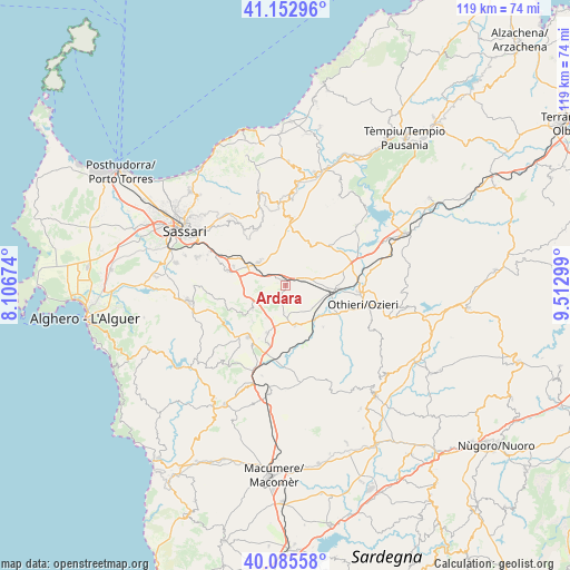
Ardara GPS coordinates[2]
40° 37' 17.04" North, 8° 48' 35.532" East
| Map corner | latitude | longitude |
|---|---|---|
| Upper-left | 41.15296°, | 8.10674° |
| Center: | 40.6214°, | 8.80987° |
| Lower-right: | 40.08558°, | 9.51299° |
| Map W x H: | 118.7×118.7 km | = 73.8×73.8mi |
| max Lat: | 47.04031° ⇑83.3% North |
| Ardara: | 40.6214° |
| min Lat: | ⇓16.7% South 35.50142° |
| min Long | Ardara | max Long |
| 6.69888° | 8.80987° | 18.48682° |
| W 16%⇐ | ⇒84% E |
Elevation
Elevation of Ardara is 302 m = 991 ft, and this is 4.7 m = 15 ft below average elevation for this country.
| Max E: |
2085 m = 6841 ft | 39.6% |
| Avg. | 306.7 m = 1006 ft | |
| Ardara | 302 m = 991 ft | |
Min E: |
-4 m = -13 ft | 60.4% |
See also: Italy elevation on elevation.city.
Geographical zone
Ardara is located in North temperate zone (between Tropic of Cancer and the Arctic Circle). Distance of this Northern Tropic circle is 1910.8 km =1187.3 mi to South.| Distance of | km | miles | from Ardara |
|---|---|---|---|
| North Pole | 5490.4 | 3411.6 | to North |
| Arctic Circle | 2884.5 | 1792.3 | to North |
| Tropic Cancer | 1910.8 | 1187.3 | to South |
| Equator | 4516.7 | 2806.5 | to South |


Nearby cities:
15 places around Ardara: (largest is in red/bold)
• Banari
10.8 km =6.7 mi,  238°
238°
• Bessude
10.2 km =6.3 mi,  223°
223°
• Bonnanaro
10.6 km =6.6 mi,  201°
201°
• Borutta
12.4 km =7.7 mi,  206°
206°
• Cheremule
14.8 km =9.2 mi, 208°
• Chiaramonti
14.1 km =8.8 mi,  3°
3°
• Codrongianos
11.5 km =7.1 mi,  289°
289°
• Florinas
12.6 km =7.8 mi,  284°
284°
• Ittireddu
11.6 km =7.2 mi,  138°
138°
• Mores
8.5 km =5.3 mi,  166°
166°
• Ploaghe
7.5 km =4.7 mi,  317°
317°
• San Nicola
15.1 km =9.4 mi,  94°
94°
• Siligo
8.6 km =5.3 mi,  233°
233°
• Thiesi
13.2 km =8.2 mi, 215°
• Torralba
12.6 km =7.8 mi, 197°
Sources, notices
• [Note1] Compared only with cities in Italy existing in our database
• [Src1] Map data: © OpenStreetMap contributors (CC-BY-SA)
• [Src2] Other city data from geonames.org with taken over terms of usage.
• [Src3] Geographical zone / Annual Mean Temperature by Robert A. Rohde @ Wikipedia
