Tula geodata
Tula (Sardinia) is a seat of a third-order administrative division; located in Italy in Europe/Rome (GMT+2) time zone. With population of 1,495 people, there are 5128 cities with bigger population in this country. Compared to other cities in Italy, 82.1% of cities are located further ↑North; 81.5% of cities are located further →East and 51.4% of cities have lower elevation than Tula. Note1


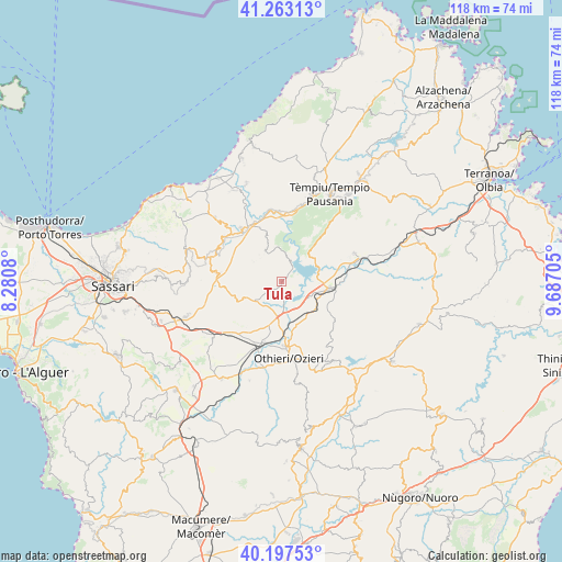
Tula GPS coordinates[2]
40° 43' 56.856" North, 8° 59' 2.112" East
| Map corner | latitude | longitude |
|---|---|---|
| Upper-left | 41.26313°, | 8.2808° |
| Center: | 40.73246°, | 8.98392° |
| Lower-right: | 40.19753°, | 9.68705° |
| Map W x H: | 118.5×118.5 km | = 73.6×73.6mi |
| max Lat: | 47.04031° ⇑82.1% North |
| Tula: | 40.73246° |
| min Lat: | ⇓17.9% South 35.50142° |
| min Long | Tula | max Long |
| 6.69888° | 8.98392° | 18.48682° |
| W 18.5%⇐ | ⇒81.5% E |
Elevation
Elevation of Tula is 243 m = 797 ft, and this is 63.7 m = 209 ft below average elevation for this country.
| Max E: |
2085 m = 6841 ft | 48.6% |
| Avg. | 306.7 m = 1006 ft | |
| Tula | 243 m = 797 ft | |
Min E: |
-4 m = -13 ft | 51.4% |
See also: Italy elevation on elevation.city.
Geographical zone
Tula is located in North temperate zone (between Tropic of Cancer and the Arctic Circle). Distance of this Northern Tropic circle is 1923.1 km =1195 mi to South.| Distance of | km | miles | from Tula |
|---|---|---|---|
| North Pole | 5478 | 3403.9 | to North |
| Arctic Circle | 2872.1 | 1784.6 | to North |
| Tropic Cancer | 1923.1 | 1195 | to South |
| Equator | 4529 | 2814.2 | to South |


Nearby cities:
15 places around Tula: (largest is in red/bold)
• Ardara
19.2 km =11.9 mi,  229°
229°
• Berchidda
16.3 km =10.1 mi,  69°
69°
• Bortigiadas
18.4 km =11.4 mi,  15°
15°
• Bulzi
18.1 km =11.2 mi,  314°
314°
• Chiaramonti
13.8 km =8.6 mi,  277°
277°
• Erula
7.5 km =4.7 mi,  333°
333°
• Laerru
15.6 km =9.7 mi, 307°
• Martis
15.6 km =9.7 mi,  288°
288°
• Nughedu San Nicolò
19.7 km =12.2 mi,  170°
170°
• Oschiri
10 km =6.2 mi,  98°
98°
• Ozieri
16.3 km =10.1 mi, 174°
• Pattada
20 km =12.4 mi,  147°
147°
• Perfugas
14 km =8.7 mi,  322°
322°
• San Nicola
13.6 km =8.5 mi,  178°
178°
• Sedini
19.4 km =12.1 mi, 313°
Sources, notices
• [Note1] Compared only with cities in Italy existing in our database
• [Src1] Map data: © OpenStreetMap contributors (CC-BY-SA)
• [Src2] Other city data from geonames.org with taken over terms of usage.
• [Src3] Geographical zone / Annual Mean Temperature by Robert A. Rohde @ Wikipedia
