Ossona geodata
Ossona (Lombardy) is a seat of a third-order administrative division; located in Italy in Europe/Rome (GMT+2) time zone. With population of 4,134 people, there are 2322 cities with bigger population in this country. Compared to other cities in Italy, 73.9% of cities are located further ↓South; 82.8% of cities are located further →East and 60.8% of cities have higher elevation than Ossona. Note1
Administrative division(s):
- Level 1: Lombardy
- Level 2: Città metropolitana di Milano
- Level 3: Ossona


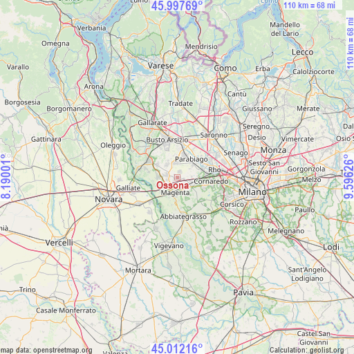
Ossona GPS coordinates[2]
45° 30' 25.488" North, 8° 53' 35.304" East
| Map corner | latitude | longitude |
|---|---|---|
| Upper-left | 45.99769°, | 8.19001° |
| Center: | 45.50708°, | 8.89314° |
| Lower-right: | 45.01216°, | 9.59626° |
| Map W x H: | 109.6×109.6 km | = 68.1×68.1mi |
| max Lat: | 47.04031° ⇑26.1% North |
| Ossona: | 45.50708° |
| min Lat: | ⇓73.9% South 35.50142° |
| min Long | Ossona | max Long |
| 6.69888° | 8.89314° | 18.48682° |
| W 17.2%⇐ | ⇒82.8% E |
Elevation
Elevation of Ossona is 157 m = 515 ft, and this is 149.7 m = 491 ft below average elevation for this country.
| Max E: |
2085 m = 6841 ft | 60.8% |
| Avg. | 306.7 m = 1006 ft | |
| Ossona | 157 m = 515 ft | |
Min E: |
-4 m = -13 ft | 39.2% |
See also: Italy elevation on elevation.city.
Geographical zone
Ossona is located in North temperate zone (between Tropic of Cancer and the Arctic Circle). Distance of this North polar circle is 2341.3 km =1454.8 mi to North.| Distance of | km | miles | from Ossona |
|---|---|---|---|
| North Pole | 4947.1 | 3074 | to North |
| Arctic Circle | 2341.3 | 1454.8 | to North |
| Tropic Cancer | 2454 | 1524.8 | to South |
| Equator | 5059.9 | 3144.1 | to South |


Nearby cities:
15 places around Ossona: (largest is in red/bold)
• Arconate
5.1 km =3.2 mi,  317°
317°
• Arluno
3.8 km =2.4 mi,  96°
96°
• Busto Garolfo
4.6 km =2.9 mi,  350°
350°
• Casate
5.4 km =3.4 mi,  251°
251°
• Casone
1.6 km =1 mi,  232°
232°
• Casorezzo
1.9 km =1.2 mi,  21°
21°
• Castellazzo
5.5 km =3.4 mi,  132°
132°
• Corbetta
4.9 km =3 mi,  155°
155°
• Furato
1.3 km =0.8 mi,  310°
310°
• Inveruno
3.5 km =2.2 mi,  282°
282°
• Magenta
4.8 km =3 mi,  188°
188°
• Marcallo
3.1 km =1.9 mi,  211°
211°
• Mesero
3 km =1.9 mi,  259°
259°
• Santo Stefano Ticino
2.9 km =1.8 mi,  142°
142°
• Vittuone
5 km =3.1 mi,  115°
115°
Sources, notices
• [Note1] Compared only with cities in Italy existing in our database
• [Src1] Map data: © OpenStreetMap contributors (CC-BY-SA)
• [Src2] Other city data from geonames.org with taken over terms of usage.
• [Src3] Geographical zone / Annual Mean Temperature by Robert A. Rohde @ Wikipedia
