Magenta geodata
Magenta (Lombardy) is a seat of a third-order administrative division; located in Italy in Europe/Rome (GMT+2) time zone. With population of 22,566 people, there are 386 cities with bigger population in this country. Compared to other cities in Italy, 72.4% of cities are located further ↓South; 83% of cities are located further →East and 63.3% of cities have higher elevation than Magenta. Note1
Administrative division(s):
- Level 1: Lombardy
- Level 2: Città metropolitana di Milano
- Level 3: Magenta


Magenta GPS coordinates[2]
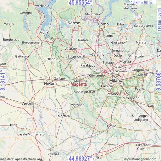
45° 27' 52.416" North, 8° 53' 4.308" East
| Map corner | latitude | longitude |
|---|---|---|
| Upper-left | 45.95554°, | 8.18141° |
| Center: | 45.46456°, | 8.88453° |
| Lower-right: | 44.96927°, | 9.58766° |
| Map W x H: | 109.7×109.7 km | = 68.2×68.2mi |
| max Lat: | 47.04031° ⇑27.6% North |
| Magenta: | 45.46456° |
| min Lat: | ⇓72.4% South 35.50142° |
| min Long | Magenta | max Long |
| 6.69888° | 8.88453° | 18.48682° |
| W 17%⇐ | ⇒83% E |
Elevation
Elevation of Magenta is 139 m = 456 ft, and this is 167.7 m = 550 ft below average elevation for this country.
| Max E: |
2085 m = 6841 ft | 63.3% |
| Avg. | 306.7 m = 1006 ft | |
| Magenta | 139 m = 456 ft | |
Min E: |
-4 m = -13 ft | 36.7% |
See also: Italy elevation on elevation.city.
Geographical zone
Magenta is located in North temperate zone (between Tropic of Cancer and the Arctic Circle). Distance of this North polar circle is 2346 km =1457.7 mi to North.| Distance of | km | miles | from Magenta |
|---|---|---|---|
| North Pole | 4951.9 | 3077 | to North |
| Arctic Circle | 2346 | 1457.7 | to North |
| Tropic Cancer | 2449.3 | 1521.9 | to South |
| Equator | 5055.2 | 3141.2 | to South |


Nearby cities:
15 places around Magenta: (largest is in red/bold)
• Bernate Ticino
5.4 km =3.4 mi,  286°
286°
• Boffalora Sopra Ticino
4.2 km =2.6 mi,  274°
274°
• Cascinazza
5.3 km =3.3 mi,  179°
179°
• Casone
3.8 km =2.4 mi,  350°
350°
• Cassinetta di Lugagnano
5 km =3.1 mi,  160°
160°
• Castellazzo
4.8 km =3 mi,  77°
77°
• Castellazzo de' Barzi
2.7 km =1.7 mi, 155°
• Casterno
4 km =2.5 mi,  196°
196°
• Cerello-Battuello
4.1 km =2.5 mi,  118°
118°
• Corbetta
2.7 km =1.7 mi, 83°
• Marcallo
2.3 km =1.4 mi,  334°
334°
• Mesero
4.8 km =3 mi, 331°
• Ossona
4.8 km =3 mi,  8°
8°
• Robecco sul Naviglio
3.1 km =1.9 mi, 178°
• Santo Stefano Ticino
3.4 km =2.1 mi,  45°
45°
Sources, notices
• [Note1] Compared only with cities in Italy existing in our database
• [Src1] Map data: © OpenStreetMap contributors (CC-BY-SA)
• [Src2] Other city data from geonames.org with taken over terms of usage.
• [Src3] Geographical zone / Annual Mean Temperature by Robert A. Rohde @ Wikipedia
