Nociglia geodata
Nociglia (Apulia) is a seat of a third-order administrative division; located in Italy in Europe/Rome (GMT+2) time zone. With population of 2,456 people, there are 3577 cities with bigger population in this country. Compared to other cities in Italy, 87.6% of cities are located further ↑North; 99.7% of cities are located further ←West and 69% of cities have higher elevation than Nociglia. Note1


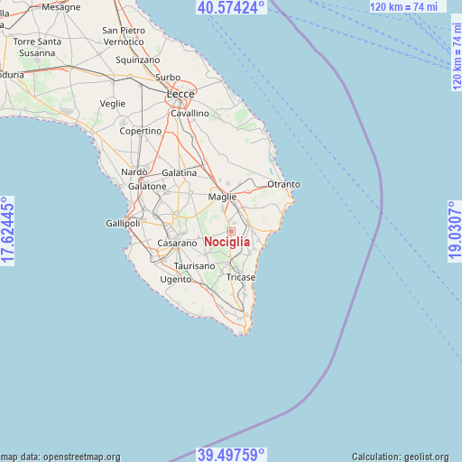
Nociglia GPS coordinates[2]
40° 2' 16.944" North, 18° 19' 39.252" East
| Map corner | latitude | longitude |
|---|---|---|
| Upper-left | 40.57424°, | 17.62445° |
| Center: | 40.03804°, | 18.32757° |
| Lower-right: | 39.49759°, | 19.0307° |
| Map W x H: | 119.7×119.7 km | = 74.4×74.4mi |
| max Lat: | 47.04031° ⇑87.6% North |
| Nociglia: | 40.03804° |
| min Lat: | ⇓12.4% South 35.50142° |
| min Long | Nociglia | max Long |
| 6.69888° | 18.32757° | 18.48682° |
| W 99.7%⇐ | ⇒0.3% E |
Elevation
Elevation of Nociglia is 103 m = 338 ft, and this is 203.7 m = 668 ft below average elevation for this country.
| Max E: |
2085 m = 6841 ft | 69% |
| Avg. | 306.7 m = 1006 ft | |
| Nociglia | 103 m = 338 ft | |
Min E: |
-4 m = -13 ft | 31% |
See also: Italy elevation on elevation.city.
Geographical zone
Nociglia is located in North temperate zone (between Tropic of Cancer and the Arctic Circle). Distance of this Northern Tropic circle is 1845.9 km =1147 mi to South.| Distance of | km | miles | from Nociglia |
|---|---|---|---|
| North Pole | 5555.2 | 3451.8 | to North |
| Arctic Circle | 2949.4 | 1832.7 | to North |
| Tropic Cancer | 1845.9 | 1147 | to South |
| Equator | 4451.8 | 2766.2 | to South |


Nearby cities:
15 places around Nociglia: (largest is in red/bold)
• Botrugno
2.9 km =1.8 mi,  351°
351°
• Castiglione
6.4 km =4 mi,  162°
162°
• Diso
6.3 km =3.9 mi,  120°
120°
• Giuggianello
7.1 km =4.4 mi,  29°
29°
• Montesano Salentino
7 km =4.3 mi,  183°
183°
• Muro Leccese
7.2 km =4.5 mi,  6°
6°
• Ortelle
5.4 km =3.4 mi,  95°
95°
• Poggiardo
4.6 km =2.9 mi,  68°
68°
• San Cassiano
2.1 km =1.3 mi, 14°
• Sanarica
5.9 km =3.7 mi,  17°
17°
• Scorrano
6.3 km =3.9 mi,  337°
337°
• Spongano
3.9 km =2.4 mi, 124°
• Surano
1.9 km =1.2 mi,  125°
125°
• Vignacastrisi
7.2 km =4.5 mi,  109°
109°
• Vitigliano
7.2 km =4.5 mi,  88°
88°
Sources, notices
• [Note1] Compared only with cities in Italy existing in our database
• [Src1] Map data: © OpenStreetMap contributors (CC-BY-SA)
• [Src2] Other city data from geonames.org with taken over terms of usage.
• [Src3] Geographical zone / Annual Mean Temperature by Robert A. Rohde @ Wikipedia
