Nepi geodata
Nepi (Latium) is a seat of a third-order administrative division; located in Italy in Europe/Rome (GMT+2) time zone. With population of 6,186 people, there are 1583 cities with bigger population in this country. Compared to other cities in Italy, 68.3% of cities are located further ↑North; 60.6% of cities are located further ←West and 52% of cities have higher elevation than Nepi. Note1


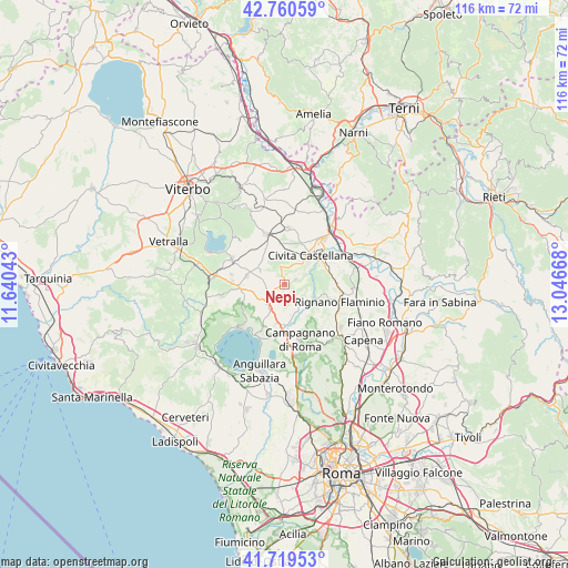
Nepi GPS coordinates[2]
42° 14' 31.956" North, 12° 20' 36.78" East
| Map corner | latitude | longitude |
|---|---|---|
| Upper-left | 42.76059°, | 11.64043° |
| Center: | 42.24221°, | 12.34355° |
| Lower-right: | 41.71953°, | 13.04668° |
| Map W x H: | 115.8×115.8 km | = 72×72mi |
| max Lat: | 47.04031° ⇑68.3% North |
| Nepi: | 42.24221° |
| min Lat: | ⇓31.7% South 35.50142° |
| min Long | Nepi | max Long |
| 6.69888° | 12.34355° | 18.48682° |
| W 60.6%⇐ | ⇒39.4% E |
Elevation
Elevation of Nepi is 222 m = 728 ft, and this is 84.7 m = 278 ft below average elevation for this country.
| Max E: |
2085 m = 6841 ft | 52% |
| Avg. | 306.7 m = 1006 ft | |
| Nepi | 222 m = 728 ft | |
Min E: |
-4 m = -13 ft | 48% |
See also: Italy elevation on elevation.city.
Geographical zone
Nepi is located in North temperate zone (between Tropic of Cancer and the Arctic Circle). Distance of this Northern Tropic circle is 2091 km =1299.3 mi to South.| Distance of | km | miles | from Nepi |
|---|---|---|---|
| North Pole | 5310.2 | 3299.6 | to North |
| Arctic Circle | 2704.3 | 1680.4 | to North |
| Tropic Cancer | 2091 | 1299.3 | to South |
| Equator | 4696.9 | 2918.5 | to South |


Nearby cities:
15 places around Nepi: (largest is in red/bold)
• Belvedere Lidia
4 km =2.5 mi,  224°
224°
• Calcata Nuova
7.3 km =4.5 mi,  110°
110°
• Carbognano
11.7 km =7.3 mi,  326°
326°
• Castel Sant'Elia
2.4 km =1.5 mi,  65°
65°
• Civita Castellana
7.8 km =4.8 mi,  43°
43°
• Colle Diana
10.9 km =6.8 mi,  280°
280°
• Colle Farnese
3.3 km =2.1 mi,  231°
231°
• Corchiano
11.5 km =7.1 mi,  5°
5°
• Fabrica di Roma
10.9 km =6.8 mi,  340°
340°
• Faleri
7.2 km =4.5 mi, 6°
• Faleria
8.6 km =5.3 mi,  102°
102°
• Mazzano Romano
5.9 km =3.7 mi,  133°
133°
• Monterosi
5.8 km =3.6 mi,  209°
209°
• Regolelli
5.7 km =3.5 mi, 6°
• Sutri
10.4 km =6.5 mi,  272°
272°
Sources, notices
• [Note1] Compared only with cities in Italy existing in our database
• [Src1] Map data: © OpenStreetMap contributors (CC-BY-SA)
• [Src2] Other city data from geonames.org with taken over terms of usage.
• [Src3] Geographical zone / Annual Mean Temperature by Robert A. Rohde @ Wikipedia
