Nemi geodata
Nemi (Latium) is a seat of a third-order administrative division; located in Italy in Europe/Rome (GMT+2) time zone. With population of 1,156 people, there are 6096 cities with bigger population in this country. Compared to other cities in Italy, 72.6% of cities are located further ↑North; 65.2% of cities are located further ←West and 85.3% of cities have lower elevation than Nemi. Note1
Administrative division(s):
- Level 1: Latium
- Level 2: Città metropolitana di Roma Capitale
- Level 3: Nemi


Nemi GPS coordinates[2]
41° 43' 18.66" North, 12° 43' 5.124" East
| Map corner | latitude | longitude |
|---|---|---|
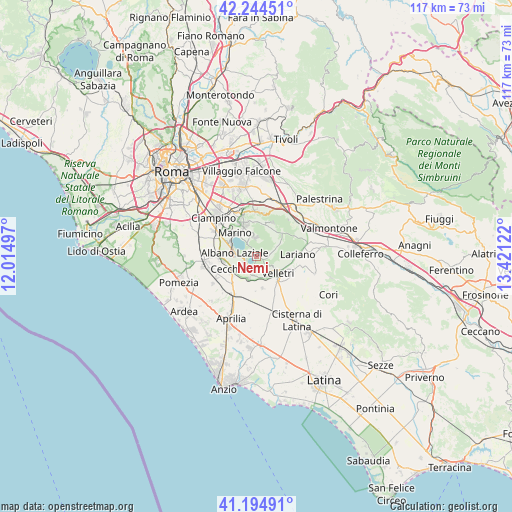
| Upper-left | 42.24451°, | 12.01497° |
| Center: | 41.72185°, | 12.71809° |
| Lower-right: | 41.19491°, | 13.42122° |
| Map W x H: | 116.7×116.7 km | = 72.5×72.5mi |
| max Lat: | 47.04031° ⇑72.6% North |
| Nemi: | 41.72185° |
| min Lat: | ⇓27.4% South 35.50142° |
| min Long | Nemi | max Long |
| 6.69888° | 12.71809° | 18.48682° |
| W 65.2%⇐ | ⇒34.8% E |
Elevation
Elevation of Nemi is 619 m = 2031 ft, and this is 312.3 m = 1025 ft above average elevation for this country.
| Max E: |
2085 m = 6841 ft | 14.7% |
| Nemi | 619 m 2031 ft | |
| Avg. | 306.7 m = 1006 ft | |
Min E: |
-4 m = -13 ft | 85.3% |
See also: Italy elevation on elevation.city.
Geographical zone
Nemi is located in North temperate zone (between Tropic of Cancer and the Arctic Circle). Distance of this Northern Tropic circle is 2033.1 km =1263.3 mi to South.| Distance of | km | miles | from Nemi |
|---|---|---|---|
| North Pole | 5368 | 3335.5 | to North |
| Arctic Circle | 2762.1 | 1716.3 | to North |
| Tropic Cancer | 2033.1 | 1263.3 | to South |
| Equator | 4639 | 2882.5 | to South |


Nearby cities:
15 places around Nemi: (largest is in red/bold)
• Albano Laziale
4.9 km =3 mi,  277°
277°
• Ariccia
3.8 km =2.4 mi,  267°
267°
• Castel Gandolfo
6.4 km =4 mi,  297°
297°
• Cecchina
6.1 km =3.8 mi,  248°
248°
• Colli di Cicerone
7.4 km =4.6 mi,  169°
169°
• Genzano di Roma
2.9 km =1.8 mi,  235°
235°
• Grottaferrata
8.2 km =5.1 mi,  331°
331°
• Landi-Pedica
9 km =5.6 mi,  181°
181°
• Lanuvio
5.8 km =3.6 mi,  200°
200°
• Lariano
9.2 km =5.7 mi,  92°
92°
• Marino
7.2 km =4.5 mi,  317°
317°
• Pavona
8.5 km =5.3 mi, 273°
• Rocca Priora
6.3 km =3.9 mi,  38°
38°
• Rocca di Papa
5.1 km =3.2 mi,  344°
344°
• Velletri
6.4 km =4 mi,  129°
129°
Sources, notices
• [Note1] Compared only with cities in Italy existing in our database
• [Src1] Map data: © OpenStreetMap contributors (CC-BY-SA)
• [Src2] Other city data from geonames.org with taken over terms of usage.
• [Src3] Geographical zone / Annual Mean Temperature by Robert A. Rohde @ Wikipedia
