Pavona geodata
Pavona (Latium) is a populated place; located in Italy in Europe/Rome (GMT+2) time zone. With population of 4,766 people, there are 2051 cities with bigger population in this country. Compared to other cities in Italy, 72.6% of cities are located further ↑North; 63.9% of cities are located further ←West and 55.5% of cities have higher elevation than Pavona. Note1
Administrative division(s):
- Level 1: Latium
- Level 2: Città metropolitana di Roma Capitale
- Level 3: Castel Gandolfo


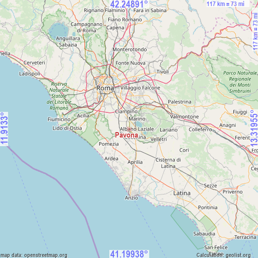
Pavona GPS coordinates[2]
41° 43' 34.644" North, 12° 36' 59.112" East
| Map corner | latitude | longitude |
|---|---|---|
| Upper-left | 42.24891°, | 11.9133° |
| Center: | 41.72629°, | 12.61642° |
| Lower-right: | 41.19938°, | 13.31955° |
| Map W x H: | 116.7×116.7 km | = 72.5×72.5mi |
| max Lat: | 47.04031° ⇑72.6% North |
| Pavona: | 41.72629° |
| min Lat: | ⇓27.4% South 35.50142° |
| min Long | Pavona | max Long |
| 6.69888° | 12.61642° | 18.48682° |
| W 63.9%⇐ | ⇒36.1% E |
Elevation
Elevation of Pavona is 199 m = 653 ft, and this is 107.7 m = 353 ft below average elevation for this country.
| Max E: |
2085 m = 6841 ft | 55.5% |
| Avg. | 306.7 m = 1006 ft | |
| Pavona | 199 m = 653 ft | |
Min E: |
-4 m = -13 ft | 44.5% |
See also: Italy elevation on elevation.city.
Geographical zone
Pavona is located in North temperate zone (between Tropic of Cancer and the Arctic Circle). Distance of this Northern Tropic circle is 2033.6 km =1263.6 mi to South.| Distance of | km | miles | from Pavona |
|---|---|---|---|
| North Pole | 5367.5 | 3335.2 | to North |
| Arctic Circle | 2761.6 | 1716 | to North |
| Tropic Cancer | 2033.6 | 1263.6 | to South |
| Equator | 4639.5 | 2882.9 | to South |


Nearby cities:
15 places around Pavona: (largest is in red/bold)
• Albano Laziale
3.5 km =2.2 mi,  87°
87°
• Ariccia
4.7 km =2.9 mi,  97°
97°
• Borgo Lotti
6.6 km =4.1 mi,  309°
309°
• Cancelliera-Massimetta-Pantanelle
2.7 km =1.7 mi,  191°
191°
• Castel Gandolfo
3.7 km =2.3 mi,  47°
47°
• Castel di Leva
8.1 km =5 mi, 313°
• Cecchina
3.9 km =2.4 mi,  134°
134°
• Genzano di Roma
6.4 km =4 mi,  109°
109°
• Grottaferrata
8.1 km =5 mi,  34°
34°
• Mantiglia di Ardea
5.5 km =3.4 mi,  181°
181°
• Marino
6 km =3.7 mi,  36°
36°
• Rocca di Papa
8.3 km =5.2 mi,  58°
58°
• Santa Palomba-Roma II
4.6 km =2.9 mi,  236°
236°
• Spregamore
5.5 km =3.4 mi,  281°
281°
• Stazione di Pavona-Palazzo Margana
2.3 km =1.4 mi,  249°
249°
Sources, notices
• [Note1] Compared only with cities in Italy existing in our database
• [Src1] Map data: © OpenStreetMap contributors (CC-BY-SA)
• [Src2] Other city data from geonames.org with taken over terms of usage.
• [Src3] Geographical zone / Annual Mean Temperature by Robert A. Rohde @ Wikipedia
