Mottalciata geodata
Mottalciata (Piedmont) is a seat of a third-order administrative division; located in Italy in Europe/Rome (GMT+2) time zone. With population of 505 people, there are 9881 cities with bigger population in this country. Compared to other cities in Italy, 73.7% of cities are located further ↓South; 91% of cities are located further →East and 54.1% of cities have higher elevation than Mottalciata. Note1


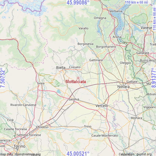
Mottalciata GPS coordinates[2]
45° 30' 0.684" North, 8° 12' 38.34" East
| Map corner | latitude | longitude |
|---|---|---|
| Upper-left | 45.99086°, | 7.50752° |
| Center: | 45.50019°, | 8.21065° |
| Lower-right: | 45.00521°, | 8.91377° |
| Map W x H: | 109.6×109.6 km | = 68.1×68.1mi |
| max Lat: | 47.04031° ⇑26.3% North |
| Mottalciata: | 45.50019° |
| min Lat: | ⇓73.7% South 35.50142° |
| min Long | Mottalciata | max Long |
| 6.69888° | 8.21065° | 18.48682° |
| W 9%⇐ | ⇒91% E |
Elevation
Elevation of Mottalciata is 209 m = 686 ft, and this is 97.7 m = 321 ft below average elevation for this country.
| Max E: |
2085 m = 6841 ft | 54.1% |
| Avg. | 306.7 m = 1006 ft | |
| Mottalciata | 209 m = 686 ft | |
Min E: |
-4 m = -13 ft | 45.9% |
See also: Italy elevation on elevation.city.
Geographical zone
Mottalciata is located in North temperate zone (between Tropic of Cancer and the Arctic Circle). Distance of this North polar circle is 2342 km =1455.3 mi to North.| Distance of | km | miles | from Mottalciata |
|---|---|---|---|
| North Pole | 4947.9 | 3074.5 | to North |
| Arctic Circle | 2342 | 1455.3 | to North |
| Tropic Cancer | 2453.2 | 1524.3 | to South |
| Equator | 5059.1 | 3143.6 | to South |


Nearby cities:
15 places around Mottalciata: (largest is in red/bold)
• Balocco
7.4 km =4.6 mi,  132°
132°
• Benna
7 km =4.3 mi,  283°
283°
• Buronzo
4.9 km =3 mi,  117°
117°
• Candelo
9.3 km =5.8 mi,  299°
299°
• Castelletto Cervo
2.6 km =1.6 mi,  26°
26°
• Cerreto Castello
8.1 km =5 mi,  331°
331°
• Cossato
8.1 km =5 mi,  345°
345°
• Gifflenga
1.9 km =1.2 mi, 115°
• Massazza
3.7 km =2.3 mi,  255°
255°
• Rovasenda
9.2 km =5.7 mi,  62°
62°
• San Giacomo Vercellese
9 km =5.6 mi,  91°
91°
• Valdengo
9.3 km =5.8 mi,  322°
322°
• Verrone
7.5 km =4.7 mi, 276°
• Vigellio
8.6 km =5.3 mi,  239°
239°
• Villanova Biellese
2.4 km =1.5 mi,  211°
211°
Sources, notices
• [Note1] Compared only with cities in Italy existing in our database
• [Src1] Map data: © OpenStreetMap contributors (CC-BY-SA)
• [Src2] Other city data from geonames.org with taken over terms of usage.
• [Src3] Geographical zone / Annual Mean Temperature by Robert A. Rohde @ Wikipedia
