Buronzo geodata
Buronzo (Piedmont) is a seat of a third-order administrative division; located in Italy in Europe/Rome (GMT+2) time zone. With population of 749 people, there are 7963 cities with bigger population in this country. Compared to other cities in Italy, 72.9% of cities are located further ↓South; 90.4% of cities are located further →East and 57.6% of cities have higher elevation than Buronzo. Note1


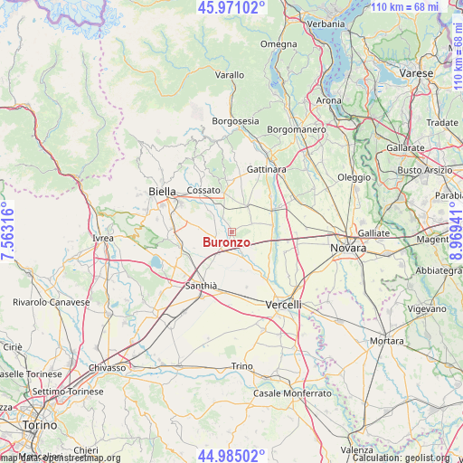
Buronzo GPS coordinates[2]
45° 28' 48.648" North, 8° 15' 58.608" East
| Map corner | latitude | longitude |
|---|---|---|
| Upper-left | 45.97102°, | 7.56316° |
| Center: | 45.48018°, | 8.26628° |
| Lower-right: | 44.98502°, | 8.96941° |
| Map W x H: | 109.6×109.6 km | = 68.1×68.1mi |
| max Lat: | 47.04031° ⇑27.1% North |
| Buronzo: | 45.48018° |
| min Lat: | ⇓72.9% South 35.50142° |
| min Long | Buronzo | max Long |
| 6.69888° | 8.26628° | 18.48682° |
| W 9.6%⇐ | ⇒90.4% E |
Elevation
Elevation of Buronzo is 183 m = 600 ft, and this is 123.7 m = 406 ft below average elevation for this country.
| Max E: |
2085 m = 6841 ft | 57.6% |
| Avg. | 306.7 m = 1006 ft | |
| Buronzo | 183 m = 600 ft | |
Min E: |
-4 m = -13 ft | 42.4% |
See also: Italy elevation on elevation.city.
Geographical zone
Buronzo is located in North temperate zone (between Tropic of Cancer and the Arctic Circle). Distance of this North polar circle is 2344.3 km =1456.7 mi to North.| Distance of | km | miles | from Buronzo |
|---|---|---|---|
| North Pole | 4950.1 | 3075.8 | to North |
| Arctic Circle | 2344.3 | 1456.7 | to North |
| Tropic Cancer | 2451 | 1523 | to South |
| Equator | 5056.9 | 3142.2 | to South |


Nearby cities:
15 places around Buronzo: (largest is in red/bold)
• Arborio
9.6 km =6 mi,  79°
79°
• Balocco
2.9 km =1.8 mi,  157°
157°
• Carisio
9.4 km =5.8 mi,  213°
213°
• Casanova Elvo
9.2 km =5.7 mi,  166°
166°
• Castelletto Cervo
5.6 km =3.5 mi,  325°
325°
• Formigliana
6 km =3.7 mi, 160°
• Ghislarengo
10.7 km =6.6 mi,  59°
59°
• Gifflenga
3 km =1.9 mi,  298°
298°
• Greggio
9.8 km =6.1 mi,  109°
109°
• Massazza
8 km =5 mi,  279°
279°
• Mottalciata
4.9 km =3 mi, 297°
• Rovasenda
7.6 km =4.7 mi,  30°
30°
• San Giacomo Vercellese
5.1 km =3.2 mi,  67°
67°
• Villanova Biellese
5.6 km =3.5 mi,  271°
271°
• Villarboit
7.3 km =4.5 mi,  130°
130°
Sources, notices
• [Note1] Compared only with cities in Italy existing in our database
• [Src1] Map data: © OpenStreetMap contributors (CC-BY-SA)
• [Src2] Other city data from geonames.org with taken over terms of usage.
• [Src3] Geographical zone / Annual Mean Temperature by Robert A. Rohde @ Wikipedia
