Montopoli geodata
Montopoli (Tuscany) is a seat of a third-order administrative division; located in Italy in Europe/Rome (GMT+2) time zone. With population of 4,019 people, there are 2383 cities with bigger population in this country. Compared to other cities in Italy, 58.4% of cities are located further ↑North; 60.4% of cities are located further →East and 76.8% of cities have higher elevation than Montopoli. Note1
Administrative division(s):
- Level 1: Tuscany
- Level 2: Province of Pisa
- Level 3: Montopoli in Val d'Arno


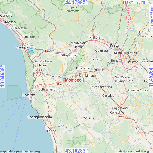
Montopoli GPS coordinates[2]
43° 40' 24.744" North, 10° 44' 58.236" East
| Map corner | latitude | longitude |
|---|---|---|
| Upper-left | 44.17995°, | 10.04639° |
| Center: | 43.67354°, | 10.74951° |
| Lower-right: | 43.16283°, | 11.45264° |
| Map W x H: | 113.1×113.1 km | = 70.3×70.3mi |
| max Lat: | 47.04031° ⇑58.4% North |
| Montopoli: | 43.67354° |
| min Lat: | ⇓41.6% South 35.50142° |
| min Long | Montopoli | max Long |
| 6.69888° | 10.74951° | 18.48682° |
| W 39.6%⇐ | ⇒60.4% E |
Elevation
Elevation of Montopoli is 65 m = 213 ft, and this is 241.7 m = 793 ft below average elevation for this country.
| Max E: |
2085 m = 6841 ft | 76.8% |
| Avg. | 306.7 m = 1006 ft | |
| Montopoli | 65 m = 213 ft | |
Min E: |
-4 m = -13 ft | 23.2% |
See also: Italy elevation on elevation.city.
Geographical zone
Montopoli is located in North temperate zone (between Tropic of Cancer and the Arctic Circle). Distance of this Northern Tropic circle is 2250.1 km =1398.1 mi to South.| Distance of | km | miles | from Montopoli |
|---|---|---|---|
| North Pole | 5151 | 3200.7 | to North |
| Arctic Circle | 2545.1 | 1581.5 | to North |
| Tropic Cancer | 2250.1 | 1398.1 | to South |
| Equator | 4856 | 3017.4 | to South |


Nearby cities:
15 places around Montopoli: (largest is in red/bold)
• Castel del Bosco
4.1 km =2.5 mi,  259°
259°
• Castelfranco di Sotto
3.4 km =2.1 mi,  355°
355°
• Cerretti
6.9 km =4.3 mi,  324°
324°
• Fucecchio
7.6 km =4.7 mi,  30°
30°
• La Rotta
6 km =3.7 mi,  253°
253°
• La Serra
6 km =3.7 mi,  121°
121°
• Marti
2.2 km =1.4 mi,  198°
198°
• Montecalvoli
6.9 km =4.3 mi,  281°
281°
• San Donato
4.5 km =2.8 mi,  43°
43°
• San Donato
4.8 km =3 mi,  273°
273°
• San Miniato Basso
7.7 km =4.8 mi,  73°
73°
• San Pierino
6.9 km =4.3 mi,  48°
48°
• San Romano
2.3 km =1.4 mi, 41°
• Santa Croce sull'Arno
5.2 km =3.2 mi,  20°
20°
• Santa Maria a Monte
6 km =3.7 mi,  309°
309°
Sources, notices
• [Note1] Compared only with cities in Italy existing in our database
• [Src1] Map data: © OpenStreetMap contributors (CC-BY-SA)
• [Src2] Other city data from geonames.org with taken over terms of usage.
• [Src3] Geographical zone / Annual Mean Temperature by Robert A. Rohde @ Wikipedia
