Montebello di Bertona geodata
Montebello di Bertona (Abruzzo) is a seat of a third-order administrative division; located in Italy in Europe/Rome (GMT+2) time zone. With population of 324 people, there are 10576 cities with bigger population in this country. Compared to other cities in Italy, 66.8% of cities are located further ↑North; 77.2% of cities are located further ←West and 83.6% of cities have lower elevation than Montebello di Bertona. Note1
Administrative division(s):
- Level 1: Abruzzo
- Level 2: Provincia di Pescara
- Level 3: Montebello di Bertona
Current local time in Montebello di Bertona:
10:34 PM, WednesdayDifference from your time zone: hours


Montebello di Bertona GPS coordinates[2]
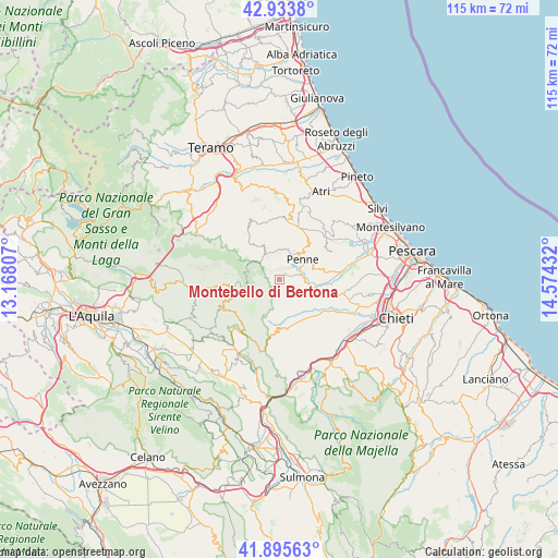
42° 25' 0.696" North, 13° 52' 16.284" East
| Map corner | latitude | longitude |
|---|---|---|
| Upper-left | 42.9338°, | 13.16807° |
| Center: | 42.41686°, | 13.87119° |
| Lower-right: | 41.89563°, | 14.57432° |
| Map W x H: | 115.4×115.4 km | = 71.7×71.7mi |
| max Lat: | 47.04031° ⇑66.8% North |
| Montebello di Bertona: | 42.41686° |
| min Lat: | ⇓33.2% South 35.50142° |
| min Long | Montebello di B | max Long |
| 6.69888° | 13.87119° | 18.48682° |
| W 77.2%⇐ | ⇒22.8% E |
Elevation
Elevation of Montebello di Bertona is 585 m = 1919 ft, and this is 278.3 m = 913 ft above average elevation for this country.
| Max E: |
2085 m = 6841 ft | 16.4% |
| Montebello di Bertona | 585 m 1919 ft | |
| Avg. | 306.7 m = 1006 ft | |
Min E: |
-4 m = -13 ft | 83.6% |
See also: Italy elevation on elevation.city.
Geographical zone
Montebello di Bertona is located in North temperate zone (between Tropic of Cancer and the Arctic Circle). Distance of this Northern Tropic circle is 2110.4 km =1311.3 mi to South.| Distance of | km | miles | from Montebello di Bertona |
|---|---|---|---|
| North Pole | 5290.7 | 3287.5 | to North |
| Arctic Circle | 2684.9 | 1668.3 | to North |
| Tropic Cancer | 2110.4 | 1311.3 | to South |
| Equator | 4716.3 | 2930.6 | to South |


Nearby cities:
15 places around Montebello di Bertona: (largest is in red/bold)
• Arsita
11.9 km =7.4 mi,  323°
323°
• Brittoli
11.3 km =7 mi,  184°
184°
• Carpineto della Nora
9.3 km =5.8 mi,  185°
185°
• Castiglione Messer Raimondo
12.8 km =8 mi,  3°
3°
• Catignano
10.2 km =6.3 mi,  139°
139°
• Civitaquana
10.4 km =6.5 mi,  166°
166°
• Civitella Casanova
6 km =3.7 mi, 168°
• Collecorvino
12.8 km =8 mi,  67°
67°
• Farindola
5 km =3.1 mi,  305°
305°
• Loreto Aprutino
9.1 km =5.7 mi,  80°
80°
• Penne
6.3 km =3.9 mi,  47°
47°
• Picciano
11.7 km =7.3 mi,  56°
56°
• Vicoli
8.7 km =5.4 mi, 165°
• Villa Celiera
4 km =2.5 mi, 194°
• Villa Santa Lucia degli Abruzzi
12.1 km =7.5 mi,  219°
219°
Sources, notices
• [Note1] Compared only with cities in Italy existing in our database
• [Src1] Map data: © OpenStreetMap contributors (CC-BY-SA)
• [Src2] Other city data from geonames.org with taken over terms of usage.
• [Src3] Geographical zone / Annual Mean Temperature by Robert A. Rohde @ Wikipedia
