Catignano geodata
Catignano (Abruzzo) is a seat of a third-order administrative division; located in Italy in Europe/Rome (GMT+2) time zone. With population of 743 people, there are 7998 cities with bigger population in this country. Compared to other cities in Italy, 67.3% of cities are located further ↑North; 77.9% of cities are located further ←West and 65.8% of cities have lower elevation than Catignano. Note1


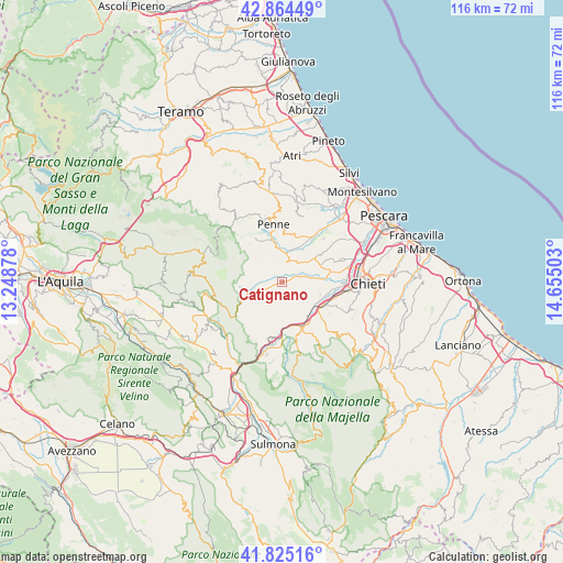
Catignano GPS coordinates[2]
42° 20' 49.092" North, 13° 57' 6.84" East
| Map corner | latitude | longitude |
|---|---|---|
| Upper-left | 42.86449°, | 13.24878° |
| Center: | 42.34697°, | 13.9519° |
| Lower-right: | 41.82516°, | 14.65503° |
| Map W x H: | 115.6×115.6 km | = 71.8×71.8mi |
| max Lat: | 47.04031° ⇑67.3% North |
| Catignano: | 42.34697° |
| min Lat: | ⇓32.7% South 35.50142° |
| min Long | Catignano | max Long |
| 6.69888° | 13.9519° | 18.48682° |
| W 77.9%⇐ | ⇒22.1% E |
Elevation
Elevation of Catignano is 351 m = 1152 ft, and this is 44.3 m = 145 ft above average elevation for this country.
| Max E: |
2085 m = 6841 ft | 34.2% |
| Catignano | 351 m 1152 ft | |
| Avg. | 306.7 m = 1006 ft | |
Min E: |
-4 m = -13 ft | 65.8% |
See also: Italy elevation on elevation.city.
Geographical zone
Catignano is located in North temperate zone (between Tropic of Cancer and the Arctic Circle). Distance of this Northern Tropic circle is 2102.6 km =1306.5 mi to South.| Distance of | km | miles | from Catignano |
|---|---|---|---|
| North Pole | 5298.5 | 3292.3 | to North |
| Arctic Circle | 2692.6 | 1673.1 | to North |
| Tropic Cancer | 2102.6 | 1306.5 | to South |
| Equator | 4708.5 | 2925.7 | to South |


Nearby cities:
15 places around Catignano: (largest is in red/bold)
• Alanno
5.9 km =3.7 mi,  164°
164°
• Brittoli
8.3 km =5.2 mi,  244°
244°
• Carpineto della Nora
7.6 km =4.7 mi,  258°
258°
• Civitaquana
4.9 km =3 mi, 241°
• Civitella Casanova
5.8 km =3.6 mi,  288°
288°
• Cugnoli
4.7 km =2.9 mi,  197°
197°
• Loreto Aprutino
9.6 km =6 mi,  14°
14°
• Manoppello Scalo
9.4 km =5.8 mi,  117°
117°
• Nocciano
3.1 km =1.9 mi, 118°
• Pietranico
8.6 km =5.3 mi, 203°
• Rosciano
8.2 km =5.1 mi,  109°
109°
• Ticchione
7.9 km =4.9 mi,  141°
141°
• Vicoli
4.6 km =2.9 mi, 261°
• Villa Celiera
8.6 km =5.3 mi,  296°
296°
• Villa Oliveti
9.5 km =5.9 mi,  95°
95°
Sources, notices
• [Note1] Compared only with cities in Italy existing in our database
• [Src1] Map data: © OpenStreetMap contributors (CC-BY-SA)
• [Src2] Other city data from geonames.org with taken over terms of usage.
• [Src3] Geographical zone / Annual Mean Temperature by Robert A. Rohde @ Wikipedia
