Loreto Aprutino geodata
Loreto Aprutino (Abruzzo) is a seat of a third-order administrative division; located in Italy in Europe/Rome (GMT+2) time zone. With population of 3,930 people, there are 2433 cities with bigger population in this country. Compared to other cities in Italy, 66.7% of cities are located further ↑North; 78.1% of cities are located further ←West and 59.8% of cities have lower elevation than Loreto Aprutino. Note1


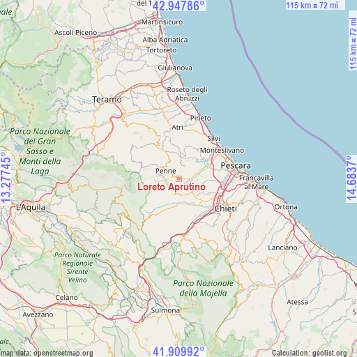
Loreto Aprutino GPS coordinates[2]
42° 25' 51.744" North, 13° 58' 50.052" East
| Map corner | latitude | longitude |
|---|---|---|
| Upper-left | 42.94786°, | 13.27745° |
| Center: | 42.43104°, | 13.98057° |
| Lower-right: | 41.90992°, | 14.6837° |
| Map W x H: | 115.4×115.4 km | = 71.7×71.7mi |
| max Lat: | 47.04031° ⇑66.7% North |
| Loreto Aprutino: | 42.43104° |
| min Lat: | ⇓33.3% South 35.50142° |
| min Long | Loreto Aprutino | max Long |
| 6.69888° | 13.98057° | 18.48682° |
| W 78.1%⇐ | ⇒21.9% E |
Elevation
Elevation of Loreto Aprutino is 298 m = 978 ft, and this is 8.7 m = 29 ft below average elevation for this country.
| Max E: |
2085 m = 6841 ft | 40.2% |
| Avg. | 306.7 m = 1006 ft | |
| Loreto Aprutino | 298 m = 978 ft | |
Min E: |
-4 m = -13 ft | 59.8% |
See also: Italy elevation on elevation.city.
Geographical zone
Loreto Aprutino is located in North temperate zone (between Tropic of Cancer and the Arctic Circle). Distance of this Northern Tropic circle is 2112 km =1312.3 mi to South.| Distance of | km | miles | from Loreto Aprutino |
|---|---|---|---|
| North Pole | 5289.2 | 3286.6 | to North |
| Arctic Circle | 2683.3 | 1667.3 | to North |
| Tropic Cancer | 2112 | 1312.3 | to South |
| Equator | 4717.9 | 2931.6 | to South |


Nearby cities:
15 places around Loreto Aprutino: (largest is in red/bold)
• Barberi
5.2 km =3.2 mi,  78°
78°
• Caprara d'Abruzzo
10.7 km =6.6 mi,  89°
89°
• Castellana
11 km =6.8 mi,  109°
109°
• Catignano
9.6 km =6 mi,  194°
194°
• Cepagatti
10.6 km =6.6 mi,  133°
133°
• Civitella Casanova
10.8 km =6.7 mi,  226°
226°
• Collecorvino
4.3 km =2.7 mi,  41°
41°
• Congiunti
9.7 km =6 mi,  62°
62°
• Elice
10.2 km =6.3 mi,  355°
355°
• Montebello di Bertona
9.1 km =5.7 mi,  260°
260°
• Moscufo
6.1 km =3.8 mi, 94°
• Nocciano
10.8 km =6.7 mi,  177°
177°
• Penne
5.1 km =3.2 mi,  301°
301°
• Pianella
6.6 km =4.1 mi,  122°
122°
• Picciano
5 km =3.1 mi,  8°
8°
Sources, notices
• [Note1] Compared only with cities in Italy existing in our database
• [Src1] Map data: © OpenStreetMap contributors (CC-BY-SA)
• [Src2] Other city data from geonames.org with taken over terms of usage.
• [Src3] Geographical zone / Annual Mean Temperature by Robert A. Rohde @ Wikipedia
