Montagano geodata
Montagano (Molise) is a seat of a third-order administrative division; located in Italy in Europe/Rome (GMT+2) time zone. With population of 1,081 people, there are 6366 cities with bigger population in this country. Compared to other cities in Italy, 73.5% of cities are located further ↑North; 84.2% of cities are located further ←West and 92.7% of cities have lower elevation than Montagano. Note1


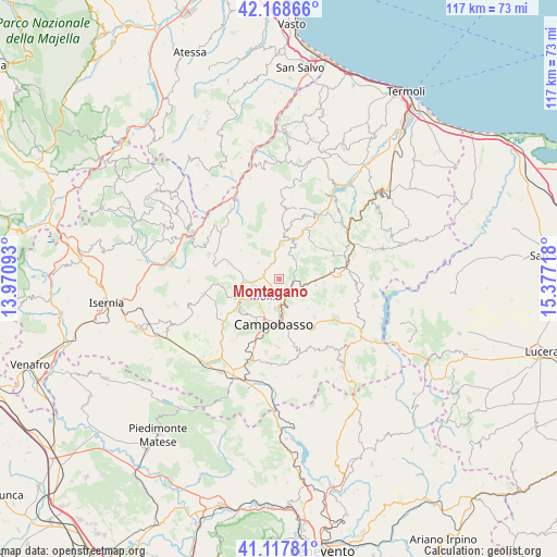
Montagano GPS coordinates[2]
41° 38' 43.368" North, 14° 40' 26.58" East
| Map corner | latitude | longitude |
|---|---|---|
| Upper-left | 42.16866°, | 13.97093° |
| Center: | 41.64538°, | 14.67405° |
| Lower-right: | 41.11781°, | 15.37718° |
| Map W x H: | 116.8×116.8 km | = 72.6×72.6mi |
| max Lat: | 47.04031° ⇑73.5% North |
| Montagano: | 41.64538° |
| min Lat: | ⇓26.5% South 35.50142° |
| min Long | Montagano | max Long |
| 6.69888° | 14.67405° | 18.48682° |
| W 84.2%⇐ | ⇒15.8% E |
Elevation
Elevation of Montagano is 791 m = 2595 ft, and this is 484.3 m = 1589 ft above average elevation for this country.
| Max E: |
2085 m = 6841 ft | 7.3% |
| Montagano | 791 m 2595 ft | |
| Avg. | 306.7 m = 1006 ft | |
Min E: |
-4 m = -13 ft | 92.7% |
See also: Italy elevation on elevation.city.
Geographical zone
Montagano is located in North temperate zone (between Tropic of Cancer and the Arctic Circle). Distance of this Northern Tropic circle is 2024.6 km =1258 mi to South.| Distance of | km | miles | from Montagano |
|---|---|---|---|
| North Pole | 5376.5 | 3340.8 | to North |
| Arctic Circle | 2770.6 | 1721.6 | to North |
| Tropic Cancer | 2024.6 | 1258 | to South |
| Equator | 4630.5 | 2877.3 | to South |


Nearby cities:
15 places around Montagano: (largest is in red/bold)
• Campobasso
9.6 km =6 mi,  183°
183°
• Campolieto
7.8 km =4.8 mi,  99°
99°
• Castellino del Biferno
7.9 km =4.9 mi,  37°
37°
• Castropignano
10.1 km =6.3 mi,  252°
252°
• Iontapede
5.5 km =3.4 mi,  193°
193°
• Limosano
5.5 km =3.4 mi,  307°
307°
• Lucito
9.7 km =6 mi,  6°
6°
• Matrice
4.2 km =2.6 mi,  134°
134°
• Oratino
9.3 km =5.8 mi,  224°
224°
• Petrella Tifernina
5.5 km =3.4 mi,  20°
20°
• Ripalimosani
4 km =2.5 mi, 193°
• S.Antonio dei Lazzari
7.7 km =4.8 mi, 181°
• San Biase
10.4 km =6.5 mi,  318°
318°
• San Giovanni in Galdo
8.9 km =5.5 mi, 132°
• Sant'Angelo Limosano
7.9 km =4.9 mi, 311°
Sources, notices
• [Note1] Compared only with cities in Italy existing in our database
• [Src1] Map data: © OpenStreetMap contributors (CC-BY-SA)
• [Src2] Other city data from geonames.org with taken over terms of usage.
• [Src3] Geographical zone / Annual Mean Temperature by Robert A. Rohde @ Wikipedia
