Limosano geodata
Limosano (Molise) is a seat of a third-order administrative division; located in Italy in Europe/Rome (GMT+2) time zone. With population of 669 people, there are 8494 cities with bigger population in this country. Compared to other cities in Italy, 73.2% of cities are located further ↑North; 83.8% of cities are located further ←West and 85.8% of cities have lower elevation than Limosano. Note1


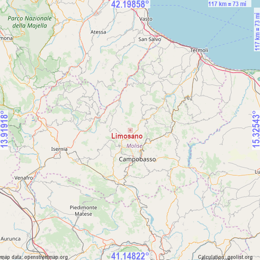
Limosano GPS coordinates[2]
41° 40' 31.944" North, 14° 37' 20.28" East
| Map corner | latitude | longitude |
|---|---|---|
| Upper-left | 42.19858°, | 13.91918° |
| Center: | 41.67554°, | 14.6223° |
| Lower-right: | 41.14822°, | 15.32543° |
| Map W x H: | 116.8×116.8 km | = 72.6×72.6mi |
| max Lat: | 47.04031° ⇑73.2% North |
| Limosano: | 41.67554° |
| min Lat: | ⇓26.8% South 35.50142° |
| min Long | Limosano | max Long |
| 6.69888° | 14.6223° | 18.48682° |
| W 83.8%⇐ | ⇒16.2% E |
Elevation
Elevation of Limosano is 629 m = 2064 ft, and this is 322.3 m = 1057 ft above average elevation for this country.
| Max E: |
2085 m = 6841 ft | 14.2% |
| Limosano | 629 m 2064 ft | |
| Avg. | 306.7 m = 1006 ft | |
Min E: |
-4 m = -13 ft | 85.8% |
See also: Italy elevation on elevation.city.
Geographical zone
Limosano is located in North temperate zone (between Tropic of Cancer and the Arctic Circle). Distance of this Northern Tropic circle is 2028 km =1260.1 mi to South.| Distance of | km | miles | from Limosano |
|---|---|---|---|
| North Pole | 5373.2 | 3338.8 | to North |
| Arctic Circle | 2767.3 | 1719.5 | to North |
| Tropic Cancer | 2028 | 1260.1 | to South |
| Equator | 4633.9 | 2879.4 | to South |


Nearby cities:
15 places around Limosano: (largest is in red/bold)
• Castelbottaccio
11.1 km =6.9 mi,  38°
38°
• Castellino del Biferno
9.5 km =5.9 mi,  72°
72°
• Castropignano
8.3 km =5.2 mi,  219°
219°
• Fossalto
6.4 km =4 mi,  267°
267°
• Iontapede
9.2 km =5.7 mi,  160°
160°
• Lucito
8.3 km =5.2 mi, 40°
• Matrice
9.6 km =6 mi,  130°
130°
• Montagano
5.5 km =3.4 mi, 127°
• Oratino
10.2 km =6.3 mi,  193°
193°
• Petrella Tifernina
6.5 km =4 mi, 74°
• Pietracupa
8.6 km =5.3 mi,  275°
275°
• Ripalimosani
8 km =5 mi,  154°
154°
• San Biase
5.1 km =3.2 mi,  329°
329°
• Sant'Angelo Limosano
2.5 km =1.6 mi,  320°
320°
• Torella del Sannio
9.4 km =5.8 mi,  244°
244°
Sources, notices
• [Note1] Compared only with cities in Italy existing in our database
• [Src1] Map data: © OpenStreetMap contributors (CC-BY-SA)
• [Src2] Other city data from geonames.org with taken over terms of usage.
• [Src3] Geographical zone / Annual Mean Temperature by Robert A. Rohde @ Wikipedia
