Melzo geodata
Melzo (Lombardy) is a seat of a third-order administrative division; located in Italy in Europe/Rome (GMT+2) time zone. With population of 18,031 people, there are 489 cities with bigger population in this country. Compared to other cities in Italy, 73.6% of cities are located further ↓South; 74.2% of cities are located further →East and 66% of cities have higher elevation than Melzo. Note1


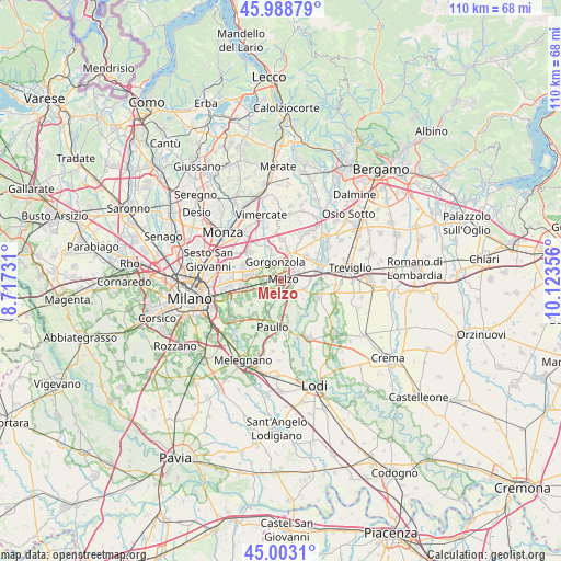
Melzo GPS coordinates[2]
45° 29' 53.16" North, 9° 25' 13.548" East
| Map corner | latitude | longitude |
|---|---|---|
| Upper-left | 45.98879°, | 8.71731° |
| Center: | 45.4981°, | 9.42043° |
| Lower-right: | 45.0031°, | 10.12356° |
| Map W x H: | 109.6×109.6 km | = 68.1×68.1mi |
| max Lat: | 47.04031° ⇑26.4% North |
| Melzo: | 45.4981° |
| min Lat: | ⇓73.6% South 35.50142° |
| min Long | Melzo | max Long |
| 6.69888° | 9.42043° | 18.48682° |
| W 25.8%⇐ | ⇒74.2% E |
Elevation
Elevation of Melzo is 121 m = 397 ft, and this is 185.7 m = 609 ft below average elevation for this country.
| Max E: |
2085 m = 6841 ft | 66% |
| Avg. | 306.7 m = 1006 ft | |
| Melzo | 121 m = 397 ft | |
Min E: |
-4 m = -13 ft | 34% |
See also: Italy elevation on elevation.city.
Geographical zone
Melzo is located in North temperate zone (between Tropic of Cancer and the Arctic Circle). Distance of this North polar circle is 2342.3 km =1455.4 mi to North.| Distance of | km | miles | from Melzo |
|---|---|---|---|
| North Pole | 4948.1 | 3074.6 | to North |
| Arctic Circle | 2342.3 | 1455.4 | to North |
| Tropic Cancer | 2453 | 1524.2 | to South |
| Equator | 5058.9 | 3143.5 | to South |


Nearby cities:
15 places around Melzo: (largest is in red/bold)
• Bellinzago Lombardo
5.3 km =3.3 mi,  22°
22°
• Bussero
5.5 km =3.4 mi,  316°
316°
• Cassina de' Pecchi
5.1 km =3.2 mi,  293°
293°
• Cavaione
2.8 km =1.7 mi,  137°
137°
• Gorgonzola
3.8 km =2.4 mi,  341°
341°
• Lavagna
4.4 km =2.7 mi,  155°
155°
• Liscate
1.8 km =1.1 mi,  205°
205°
• Pozzuolo Martesana
3.3 km =2.1 mi,  57°
57°
• Premenugo
4.4 km =2.7 mi,  219°
219°
• Sant'Agata Martesana
3.9 km =2.4 mi,  313°
313°
• Settala
5.6 km =3.5 mi, 207°
• Trecella
4.9 km =3 mi,  67°
67°
• Truccazzano
4.1 km =2.5 mi,  111°
111°
• Vignate
3.4 km =2.1 mi,  272°
272°
• Villaggio Residenziale
5 km =3.1 mi,  47°
47°
Sources, notices
• [Note1] Compared only with cities in Italy existing in our database
• [Src1] Map data: © OpenStreetMap contributors (CC-BY-SA)
• [Src2] Other city data from geonames.org with taken over terms of usage.
• [Src3] Geographical zone / Annual Mean Temperature by Robert A. Rohde @ Wikipedia
