Gorgonzola geodata
Gorgonzola (Lombardy) is a seat of a third-order administrative division; located in Italy in Europe/Rome (GMT+2) time zone. With population of 18,979 people, there are 463 cities with bigger population in this country. Compared to other cities in Italy, 74.7% of cities are located further ↓South; 74.4% of cities are located further →East and 63.4% of cities have higher elevation than Gorgonzola. Note1
Administrative division(s):
- Level 1: Lombardy
- Level 2: Città metropolitana di Milano
- Level 3: Gorgonzola


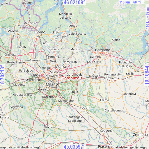
Gorgonzola GPS coordinates[2]
45° 31' 50.484" North, 9° 24' 19.116" East
| Map corner | latitude | longitude |
|---|---|---|
| Upper-left | 46.02109°, | 8.70218° |
| Center: | 45.53069°, | 9.40531° |
| Lower-right: | 45.03597°, | 10.10844° |
| Map W x H: | 109.5×109.5 km | = 68×68mi |
| max Lat: | 47.04031° ⇑25.3% North |
| Gorgonzola: | 45.53069° |
| min Lat: | ⇓74.7% South 35.50142° |
| min Long | Gorgonzola | max Long |
| 6.69888° | 9.40531° | 18.48682° |
| W 25.6%⇐ | ⇒74.4% E |
Elevation
Elevation of Gorgonzola is 138 m = 453 ft, and this is 168.7 m = 553 ft below average elevation for this country.
| Max E: |
2085 m = 6841 ft | 63.4% |
| Avg. | 306.7 m = 1006 ft | |
| Gorgonzola | 138 m = 453 ft | |
Min E: |
-4 m = -13 ft | 36.6% |
See also: Italy elevation on elevation.city.
Geographical zone
Gorgonzola is located in North temperate zone (between Tropic of Cancer and the Arctic Circle). Distance of this North polar circle is 2338.6 km =1453.1 mi to North.| Distance of | km | miles | from Gorgonzola |
|---|---|---|---|
| North Pole | 4944.5 | 3072.4 | to North |
| Arctic Circle | 2338.6 | 1453.1 | to North |
| Tropic Cancer | 2456.6 | 1526.5 | to South |
| Equator | 5062.5 | 3145.7 | to South |


Nearby cities:
15 places around Gorgonzola: (largest is in red/bold)
• Bellinzago Lombardo
3.4 km =2.1 mi,  68°
68°
• Bussero
2.6 km =1.6 mi,  278°
278°
• Caponago
4.6 km =2.9 mi,  330°
330°
• Carugate
5.5 km =3.4 mi,  292°
292°
• Cassina de' Pecchi
3.9 km =2.4 mi,  245°
245°
• Gessate
3.2 km =2 mi,  52°
52°
• Liscate
5.3 km =3.3 mi,  175°
175°
• Melzo
3.8 km =2.4 mi,  161°
161°
• Pessano Con Bornago
2.8 km =1.7 mi,  318°
318°
• Pozzuolo Martesana
4.4 km =2.7 mi,  115°
115°
• Ronco
3.6 km =2.2 mi,  262°
262°
• Sant'Agata Martesana
1.9 km =1.2 mi,  240°
240°
• Torrazza dei Mandelli
4 km =2.5 mi,  353°
353°
• Vignate
4.1 km =2.5 mi,  212°
212°
• Villaggio Residenziale
4.8 km =3 mi,  93°
93°
Sources, notices
• [Note1] Compared only with cities in Italy existing in our database
• [Src1] Map data: © OpenStreetMap contributors (CC-BY-SA)
• [Src2] Other city data from geonames.org with taken over terms of usage.
• [Src3] Geographical zone / Annual Mean Temperature by Robert A. Rohde @ Wikipedia
