Cavaione geodata
Cavaione (Lombardy) is a populated place; located in Italy in Europe/Rome (GMT+2) time zone. With population of 839 people, there are 7451 cities with bigger population in this country. Compared to other cities in Italy, 72.9% of cities are located further ↓South; 73.9% of cities are located further →East and 68.8% of cities have higher elevation than Cavaione. Note1
Administrative division(s):
- Level 1: Lombardy
- Level 2: Città metropolitana di Milano
- Level 3: Truccazzano


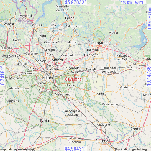
Cavaione GPS coordinates[2]
45° 28' 46.092" North, 9° 26' 41.028" East
| Map corner | latitude | longitude |
|---|---|---|
| Upper-left | 45.97032°, | 8.74161° |
| Center: | 45.47947°, | 9.44473° |
| Lower-right: | 44.98431°, | 10.14786° |
| Map W x H: | 109.6×109.6 km | = 68.1×68.1mi |
| max Lat: | 47.04031° ⇑27.1% North |
| Cavaione: | 45.47947° |
| min Lat: | ⇓72.9% South 35.50142° |
| min Long | Cavaione | max Long |
| 6.69888° | 9.44473° | 18.48682° |
| W 26.1%⇐ | ⇒73.9% E |
Elevation
Elevation of Cavaione is 104 m = 341 ft, and this is 202.7 m = 665 ft below average elevation for this country.
| Max E: |
2085 m = 6841 ft | 68.8% |
| Avg. | 306.7 m = 1006 ft | |
| Cavaione | 104 m = 341 ft | |
Min E: |
-4 m = -13 ft | 31.2% |
See also: Italy elevation on elevation.city.
Geographical zone
Cavaione is located in North temperate zone (between Tropic of Cancer and the Arctic Circle). Distance of this North polar circle is 2344.3 km =1456.7 mi to North.| Distance of | km | miles | from Cavaione |
|---|---|---|---|
| North Pole | 4950.2 | 3075.9 | to North |
| Arctic Circle | 2344.3 | 1456.7 | to North |
| Tropic Cancer | 2450.9 | 1522.9 | to South |
| Equator | 5056.8 | 3142.1 | to South |


Nearby cities:
15 places around Cavaione: (largest is in red/bold)
• Albignano
4.4 km =2.7 mi,  58°
58°
• Comazzo
4.4 km =2.7 mi,  161°
161°
• Gorgonzola
6.5 km =4 mi,  331°
331°
• Lavagna
2 km =1.2 mi,  181°
181°
• Liscate
2.7 km =1.7 mi,  278°
278°
• Melzo
2.8 km =1.7 mi,  317°
317°
• Merlino
5.3 km =3.3 mi,  192°
192°
• Pozzuolo Martesana
3.9 km =2.4 mi,  13°
13°
• Premenugo
4.9 km =3 mi,  254°
254°
• Rivolta d'Adda
5.4 km =3.4 mi,  101°
101°
• Settala
5.3 km =3.3 mi,  237°
237°
• Trecella
4.8 km =3 mi,  34°
34°
• Truccazzano
2 km =1.2 mi,  73°
73°
• Vignate
5.7 km =3.5 mi,  292°
292°
• Villaggio Residenziale
5.7 km =3.5 mi,  18°
18°
Sources, notices
• [Note1] Compared only with cities in Italy existing in our database
• [Src1] Map data: © OpenStreetMap contributors (CC-BY-SA)
• [Src2] Other city data from geonames.org with taken over terms of usage.
• [Src3] Geographical zone / Annual Mean Temperature by Robert A. Rohde @ Wikipedia
