Mel geodata
Mel (Veneto) is a seat of a third-order administrative division; located in Italy in Europe/Rome (GMT+2) time zone. With population of 1,744 people, there are 4581 cities with bigger population in this country. Compared to other cities in Italy, 93.3% of cities are located further ↓South; 57.1% of cities are located further ←West and 62.5% of cities have lower elevation than Mel. Note1


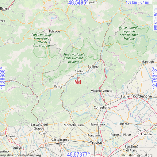
Mel GPS coordinates[2]
46° 3' 49.644" North, 12° 5' 24" East
| Map corner | latitude | longitude |
|---|---|---|
| Upper-left | 46.5495°, | 11.38688° |
| Center: | 46.06379°, | 12.09° |
| Lower-right: | 45.57377°, | 12.79313° |
| Map W x H: | 108.5×108.5 km | = 67.4×67.4mi |
| max Lat: | 47.04031° ⇑6.7% North |
| Mel: | 46.06379° |
| min Lat: | ⇓93.3% South 35.50142° |
| min Long | Mel | max Long |
| 6.69888° | 12.09° | 18.48682° |
| W 57.1%⇐ | ⇒42.9% E |
Elevation
Elevation of Mel is 319 m = 1047 ft, and this is 12.3 m = 40 ft above average elevation for this country.
| Max E: |
2085 m = 6841 ft | 37.5% |
| Mel | 319 m 1047 ft | |
| Avg. | 306.7 m = 1006 ft | |
Min E: |
-4 m = -13 ft | 62.5% |
See also: Italy elevation on elevation.city.
Geographical zone
Mel is located in North temperate zone (between Tropic of Cancer and the Arctic Circle). Distance of this North polar circle is 2279.4 km =1416.4 mi to North.| Distance of | km | miles | from Mel |
|---|---|---|---|
| North Pole | 4885.2 | 3035.5 | to North |
| Arctic Circle | 2279.4 | 1416.4 | to North |
| Tropic Cancer | 2515.9 | 1563.3 | to South |
| Equator | 5121.8 | 3182.5 | to South |


Nearby cities:
15 places around Mel: (largest is in red/bold)
• Cesiomaggiore
8.5 km =5.3 mi,  287°
287°
• Lentiai
5.8 km =3.6 mi,  248°
248°
• Limana
8.4 km =5.2 mi,  61°
61°
• Mas
10.3 km =6.4 mi,  17°
17°
• Meano
4.9 km =3 mi,  333°
333°
• Mis
10 km =6.2 mi,  358°
358°
• Roe Alte
8.1 km =5 mi, 15°
• San Gregorio nelle Alpi
6.6 km =4.1 mi,  312°
312°
• Santa Giustina
4.4 km =2.7 mi,  295°
295°
• Sedico
4.7 km =2.9 mi,  3°
3°
• Sospirolo
8.7 km =5.4 mi,  351°
351°
• Trichiana
4.4 km =2.7 mi, 63°
• Villa di Villa
3.1 km =1.9 mi,  220°
220°
• Villapiana-Ronchena
7.7 km =4.8 mi,  244°
244°
• Visome
10.3 km =6.4 mi, 56°
Sources, notices
• [Note1] Compared only with cities in Italy existing in our database
• [Src1] Map data: © OpenStreetMap contributors (CC-BY-SA)
• [Src2] Other city data from geonames.org with taken over terms of usage.
• [Src3] Geographical zone / Annual Mean Temperature by Robert A. Rohde @ Wikipedia
