Lentiai geodata
Lentiai (Veneto) is a seat of a third-order administrative division; located in Italy in Europe/Rome (GMT+2) time zone. With population of 1,448 people, there are 5252 cities with bigger population in this country. Compared to other cities in Italy, 92.9% of cities are located further ↓South; 56.1% of cities are located further ←West and 54.1% of cities have lower elevation than Lentiai. Note1


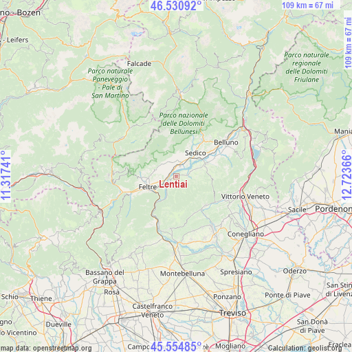
Lentiai GPS coordinates[2]
46° 2' 42.144" North, 12° 1' 13.908" East
| Map corner | latitude | longitude |
|---|---|---|
| Upper-left | 46.53092°, | 11.31741° |
| Center: | 46.04504°, | 12.02053° |
| Lower-right: | 45.55485°, | 12.72366° |
| Map W x H: | 108.5×108.5 km | = 67.4×67.4mi |
| max Lat: | 47.04031° ⇑7.1% North |
| Lentiai: | 46.04504° |
| min Lat: | ⇓92.9% South 35.50142° |
| min Long | Lentiai | max Long |
| 6.69888° | 12.02053° | 18.48682° |
| W 56.1%⇐ | ⇒43.9% E |
Elevation
Elevation of Lentiai is 260 m = 853 ft, and this is 46.7 m = 153 ft below average elevation for this country.
| Max E: |
2085 m = 6841 ft | 45.9% |
| Avg. | 306.7 m = 1006 ft | |
| Lentiai | 260 m = 853 ft | |
Min E: |
-4 m = -13 ft | 54.1% |
See also: Italy elevation on elevation.city.
Geographical zone
Lentiai is located in North temperate zone (between Tropic of Cancer and the Arctic Circle). Distance of this North polar circle is 2281.4 km =1417.6 mi to North.| Distance of | km | miles | from Lentiai |
|---|---|---|---|
| North Pole | 4887.3 | 3036.8 | to North |
| Arctic Circle | 2281.4 | 1417.6 | to North |
| Tropic Cancer | 2513.8 | 1562 | to South |
| Equator | 5119.7 | 3181.2 | to South |


Nearby cities:
15 places around Lentiai: (largest is in red/bold)
• Anzù
7.9 km =4.9 mi,  239°
239°
• Cesiomaggiore
5.4 km =3.4 mi,  329°
329°
• Feltre
9.7 km =6 mi,  253°
253°
• Foen
8.6 km =5.3 mi,  266°
266°
• Meano
7.3 km =4.5 mi,  26°
26°
• Mel
5.8 km =3.6 mi,  68°
68°
• Pedavena
10.6 km =6.6 mi, 266°
• San Gregorio nelle Alpi
6.6 km =4.1 mi,  4°
4°
• Santa Giustina
4.2 km =2.6 mi,  18°
18°
• Sedico
8.8 km =5.5 mi,  39°
39°
• Sospirolo
11.5 km =7.1 mi, 20°
• Trichiana
10.1 km =6.3 mi, 66°
• Villa di Villa
3.3 km =2.1 mi,  95°
95°
• Villabruna-Umin
7.3 km =4.5 mi,  280°
280°
• Villapiana-Ronchena
2.1 km =1.3 mi,  230°
230°
Sources, notices
• [Note1] Compared only with cities in Italy existing in our database
• [Src1] Map data: © OpenStreetMap contributors (CC-BY-SA)
• [Src2] Other city data from geonames.org with taken over terms of usage.
• [Src3] Geographical zone / Annual Mean Temperature by Robert A. Rohde @ Wikipedia
