Villapiana-Ronchena geodata
Villapiana-Ronchena (Veneto) is a populated place; located in Italy in Europe/Rome (GMT+2) time zone. With population of 992 people, there are 6706 cities with bigger population in this country. Compared to other cities in Italy, 92.7% of cities are located further ↓South; 55.8% of cities are located further ←West and 50.4% of cities have lower elevation than Villapiana-Ronchena. Note1


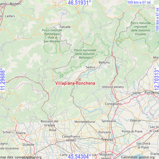
Villapiana-Ronchena GPS coordinates[2]
46° 1' 59.988" North, 12° 0' 0" East
| Map corner | latitude | longitude |
|---|---|---|
| Upper-left | 46.51931°, | 11.29688° |
| Center: | 46.03333°, | 12° |
| Lower-right: | 45.54304°, | 12.70313° |
| Map W x H: | 108.6×108.6 km | = 67.5×67.5mi |
| max Lat: | 47.04031° ⇑7.3% North |
| Villapiana-Ronchena: | 46.03333° |
| min Lat: | ⇓92.7% South 35.50142° |
| min Long | Villapiana-Ronc | max Long |
| 6.69888° | 12° | 18.48682° |
| W 55.8%⇐ | ⇒44.2% E |
Elevation
Elevation of Villapiana-Ronchena is 237 m = 778 ft, and this is 69.7 m = 229 ft below average elevation for this country.
| Max E: |
2085 m = 6841 ft | 49.6% |
| Avg. | 306.7 m = 1006 ft | |
| Villapiana-Ronchena | 237 m = 778 ft | |
Min E: |
-4 m = -13 ft | 50.4% |
See also: Italy elevation on elevation.city.
Geographical zone
Villapiana-Ronchena is located in North temperate zone (between Tropic of Cancer and the Arctic Circle). Distance of this North polar circle is 2282.7 km =1418.4 mi to North.| Distance of | km | miles | from Villapiana-Ronchena |
|---|---|---|---|
| North Pole | 4888.6 | 3037.6 | to North |
| Arctic Circle | 2282.7 | 1418.4 | to North |
| Tropic Cancer | 2512.5 | 1561.2 | to South |
| Equator | 5118.4 | 3180.4 | to South |


Nearby cities:
15 places around Villapiana-Ronchena: (largest is in red/bold)
• Anzù
5.8 km =3.6 mi,  242°
242°
• Cesiomaggiore
6 km =3.7 mi,  349°
349°
• Facen-Travagola
10.6 km =6.6 mi,  267°
267°
• Feltre
7.8 km =4.8 mi,  259°
259°
• Foen
7 km =4.3 mi,  276°
276°
• Lentiai
2.1 km =1.3 mi,  50°
50°
• Meano
9.2 km =5.7 mi,  31°
31°
• Mel
7.7 km =4.8 mi,  64°
64°
• Pedavena
9 km =5.6 mi, 274°
• San Gregorio nelle Alpi
8.1 km =5 mi,  14°
14°
• Santa Giustina
6.1 km =3.8 mi, 28°
• Sedico
10.8 km =6.7 mi,  41°
41°
• Vas
11.7 km =7.3 mi,  205°
205°
• Villa di Villa
5 km =3.1 mi,  78°
78°
• Villabruna-Umin
6.2 km =3.9 mi,  294°
294°
Sources, notices
• [Note1] Compared only with cities in Italy existing in our database
• [Src1] Map data: © OpenStreetMap contributors (CC-BY-SA)
• [Src2] Other city data from geonames.org with taken over terms of usage.
• [Src3] Geographical zone / Annual Mean Temperature by Robert A. Rohde @ Wikipedia
