Meda geodata
Meda (Lombardy) is a seat of a third-order administrative division; located in Italy in Europe/Rome (GMT+2) time zone. With population of 22,665 people, there are 379 cities with bigger population in this country. Compared to other cities in Italy, 79.5% of cities are located further ↓South; 78.8% of cities are located further →East and 52.2% of cities have higher elevation than Meda. Note1
Administrative division(s):
- Level 1: Lombardy
- Level 2: Provincia di Monza e della Brianza
- Level 3: Meda


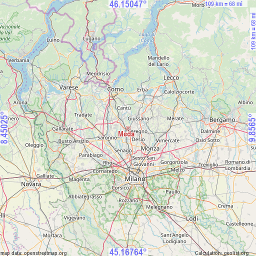
Meda GPS coordinates[2]
45° 39' 40.356" North, 9° 9' 12.132" East
| Map corner | latitude | longitude |
|---|---|---|
| Upper-left | 46.15047°, | 8.45025° |
| Center: | 45.66121°, | 9.15337° |
| Lower-right: | 45.16764°, | 9.8565° |
| Map W x H: | 109.3×109.3 km | = 67.9×67.9mi |
| max Lat: | 47.04031° ⇑20.5% North |
| Meda: | 45.66121° |
| min Lat: | ⇓79.5% South 35.50142° |
| min Long | Meda | max Long |
| 6.69888° | 9.15337° | 18.48682° |
| W 21.2%⇐ | ⇒78.8% E |
Elevation
Elevation of Meda is 221 m = 725 ft, and this is 85.7 m = 281 ft below average elevation for this country.
| Max E: |
2085 m = 6841 ft | 52.2% |
| Avg. | 306.7 m = 1006 ft | |
| Meda | 221 m = 725 ft | |
Min E: |
-4 m = -13 ft | 47.8% |
See also: Italy elevation on elevation.city.
Geographical zone
Meda is located in North temperate zone (between Tropic of Cancer and the Arctic Circle). Distance of this North polar circle is 2324.1 km =1444.1 mi to North.| Distance of | km | miles | from Meda |
|---|---|---|---|
| North Pole | 4930 | 3063.4 | to North |
| Arctic Circle | 2324.1 | 1444.1 | to North |
| Tropic Cancer | 2471.1 | 1535.5 | to South |
| Equator | 5077.1 | 3154.8 | to South |


Nearby cities:
15 places around Meda: (largest is in red/bold)
• Barlassina
2 km =1.2 mi,  251°
251°
• Bovisio-Masciago
5.7 km =3.5 mi,  180°
180°
• Cabiate
2.1 km =1.3 mi,  47°
47°
• Cascina Valle-Stazione di Carimate
5 km =3.1 mi,  318°
318°
• Cesano Maderno
3.6 km =2.2 mi, 181°
• Cimnago
3.6 km =2.2 mi,  327°
327°
• Cogliate
6 km =3.7 mi, 253°
• Figino Serenza
5.7 km =3.5 mi,  342°
342°
• Lazzate
5.5 km =3.4 mi,  282°
282°
• Lentate sul Seveso
3.2 km =2 mi,  301°
301°
• Mariano Comense
4.5 km =2.8 mi,  29°
29°
• Misinto
5.6 km =3.5 mi,  270°
270°
• Novedrate
4.8 km =3 mi, 328°
• Seregno
4.2 km =2.6 mi,  107°
107°
• Seveso
1.8 km =1.1 mi,  206°
206°
Sources, notices
• [Note1] Compared only with cities in Italy existing in our database
• [Src1] Map data: © OpenStreetMap contributors (CC-BY-SA)
• [Src2] Other city data from geonames.org with taken over terms of usage.
• [Src3] Geographical zone / Annual Mean Temperature by Robert A. Rohde @ Wikipedia
