Cogliate geodata
Cogliate (Lombardy) is a seat of a third-order administrative division; located in Italy in Europe/Rome (GMT+2) time zone. With population of 8,450 people, there are 1134 cities with bigger population in this country. Compared to other cities in Italy, 78.9% of cities are located further ↓South; 80% of cities are located further →East and 50.6% of cities have higher elevation than Cogliate. Note1
Administrative division(s):
- Level 1: Lombardy
- Level 2: Provincia di Monza e della Brianza
- Level 3: Cogliate


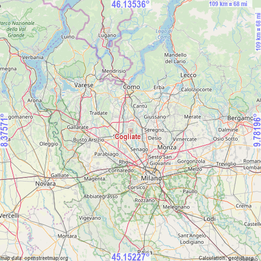
Cogliate GPS coordinates[2]
45° 38' 45.492" North, 9° 4' 43.824" East
| Map corner | latitude | longitude |
|---|---|---|
| Upper-left | 46.13536°, | 8.37571° |
| Center: | 45.64597°, | 9.07884° |
| Lower-right: | 45.15227°, | 9.78196° |
| Map W x H: | 109.3×109.3 km | = 67.9×67.9mi |
| max Lat: | 47.04031° ⇑21.1% North |
| Cogliate: | 45.64597° |
| min Lat: | ⇓78.9% South 35.50142° |
| min Long | Cogliate | max Long |
| 6.69888° | 9.07884° | 18.48682° |
| W 20%⇐ | ⇒80% E |
Elevation
Elevation of Cogliate is 231 m = 758 ft, and this is 75.7 m = 248 ft below average elevation for this country.
| Max E: |
2085 m = 6841 ft | 50.6% |
| Avg. | 306.7 m = 1006 ft | |
| Cogliate | 231 m = 758 ft | |
Min E: |
-4 m = -13 ft | 49.4% |
See also: Italy elevation on elevation.city.
Geographical zone
Cogliate is located in North temperate zone (between Tropic of Cancer and the Arctic Circle). Distance of this North polar circle is 2325.8 km =1445.2 mi to North.| Distance of | km | miles | from Cogliate |
|---|---|---|---|
| North Pole | 4931.7 | 3064.4 | to North |
| Arctic Circle | 2325.8 | 1445.2 | to North |
| Tropic Cancer | 2469.4 | 1534.4 | to South |
| Equator | 5075.4 | 3153.7 | to South |


Nearby cities:
15 places around Cogliate: (largest is in red/bold)
• Barlassina
4 km =2.5 mi,  74°
74°
• Cascina Nuova
1.4 km =0.9 mi,  304°
304°
• Ceriano Laghetto
1.9 km =1.2 mi,  176°
176°
• Cesate
5.6 km =3.5 mi, 182°
• Dal Pozzo
2.5 km =1.6 mi,  229°
229°
• Lazzate
2.9 km =1.8 mi,  8°
8°
• Lentate sul Seveso
4.5 km =2.8 mi,  41°
41°
• Manera
4.3 km =2.7 mi,  315°
315°
• Misinto
1.7 km =1.1 mi, 6°
• Rovellasca
3.3 km =2.1 mi,  314°
314°
• Rovello Porro
3.1 km =1.9 mi,  282°
282°
• Saronno
4.1 km =2.5 mi,  235°
235°
• Seveso
5 km =3.1 mi,  89°
89°
• Solaro
3.5 km =2.2 mi,  174°
174°
• Villaggio del Sole
4.2 km =2.6 mi,  148°
148°
Sources, notices
• [Note1] Compared only with cities in Italy existing in our database
• [Src1] Map data: © OpenStreetMap contributors (CC-BY-SA)
• [Src2] Other city data from geonames.org with taken over terms of usage.
• [Src3] Geographical zone / Annual Mean Temperature by Robert A. Rohde @ Wikipedia
