Mattinata geodata
Mattinata (Apulia) is a seat of a third-order administrative division; located in Italy in Europe/Rome (GMT+2) time zone. With population of 5,727 people, there are 1717 cities with bigger population in this country. Compared to other cities in Italy, 72.8% of cities are located further ↑North; 93.1% of cities are located further ←West and 72.8% of cities have higher elevation than Mattinata. Note1


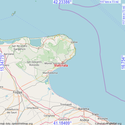
Mattinata GPS coordinates[2]
41° 42' 40.032" North, 16° 3' 3.132" East
| Map corner | latitude | longitude |
|---|---|---|
| Upper-left | 42.23386°, | 15.34775° |
| Center: | 41.71112°, | 16.05087° |
| Lower-right: | 41.18409°, | 16.754° |
| Map W x H: | 116.7×116.7 km | = 72.5×72.5mi |
| max Lat: | 47.04031° ⇑72.8% North |
| Mattinata: | 41.71112° |
| min Lat: | ⇓27.2% South 35.50142° |
| min Long | Mattinata | max Long |
| 6.69888° | 16.05087° | 18.48682° |
| W 93.1%⇐ | ⇒6.9% E |
Elevation
Elevation of Mattinata is 84 m = 276 ft, and this is 222.7 m = 731 ft below average elevation for this country.
| Max E: |
2085 m = 6841 ft | 72.8% |
| Avg. | 306.7 m = 1006 ft | |
| Mattinata | 84 m = 276 ft | |
Min E: |
-4 m = -13 ft | 27.2% |
See also: Italy elevation on elevation.city.
Geographical zone
Mattinata is located in North temperate zone (between Tropic of Cancer and the Arctic Circle). Distance of this Northern Tropic circle is 2031.9 km =1262.6 mi to South.| Distance of | km | miles | from Mattinata |
|---|---|---|---|
| North Pole | 5369.2 | 3336.3 | to North |
| Arctic Circle | 2763.3 | 1717 | to North |
| Tropic Cancer | 2031.9 | 1262.6 | to South |
| Equator | 4637.8 | 2881.8 | to South |


Nearby cities:
15 places around Mattinata: (largest is in red/bold)
• Borgo Celano
32.7 km =20.3 mi,  268°
268°
• Cagnano Varano
26.5 km =16.5 mi,  299°
299°
• Carpino
21.9 km =13.6 mi,  312°
312°
• Ischitella
24.9 km =15.5 mi,  329°
329°
• Manfredonia
14.2 km =8.8 mi,  230°
230°
• Margherita di Savoia
38.7 km =24 mi,  167°
167°
• Monte Sant'Angelo
7.5 km =4.7 mi, 265°
• Peschici
26.2 km =16.3 mi,  353°
353°
• Rignano Garganico
38.6 km =24 mi,  264°
264°
• Rodi Garganico
27.8 km =17.3 mi, 329°
• San Giovanni Rotondo
26.8 km =16.7 mi, 268°
• San Marco in Lamis
34.2 km =21.3 mi, 270°
• Vico del Gargano
22 km =13.7 mi,  339°
339°
• Vieste
21.5 km =13.4 mi,  27°
27°
• Zapponeta
29.3 km =18.2 mi,  195°
195°
Sources, notices
• [Note1] Compared only with cities in Italy existing in our database
• [Src1] Map data: © OpenStreetMap contributors (CC-BY-SA)
• [Src2] Other city data from geonames.org with taken over terms of usage.
• [Src3] Geographical zone / Annual Mean Temperature by Robert A. Rohde @ Wikipedia
