Ischitella geodata
Ischitella (Apulia) is a seat of a third-order administrative division; located in Italy in Europe/Rome (GMT+2) time zone. With population of 3,531 people, there are 2659 cities with bigger population in this country. Compared to other cities in Italy, 71.2% of cities are located further ↑North; 92.2% of cities are located further ←West and 63.3% of cities have lower elevation than Ischitella. Note1


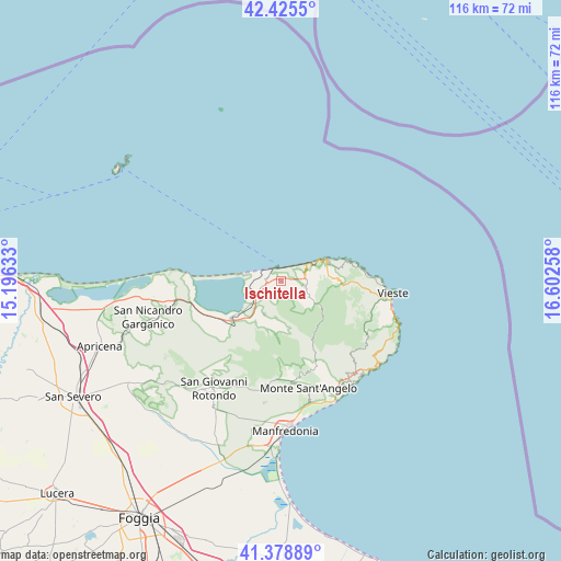
Ischitella GPS coordinates[2]
41° 54' 15.624" North, 15° 53' 58.02" East
| Map corner | latitude | longitude |
|---|---|---|
| Upper-left | 42.4255°, | 15.19633° |
| Center: | 41.90434°, | 15.89945° |
| Lower-right: | 41.37889°, | 16.60258° |
| Map W x H: | 116.4×116.4 km | = 72.3×72.3mi |
| max Lat: | 47.04031° ⇑71.2% North |
| Ischitella: | 41.90434° |
| min Lat: | ⇓28.8% South 35.50142° |
| min Long | Ischitella | max Long |
| 6.69888° | 15.89945° | 18.48682° |
| W 92.2%⇐ | ⇒7.8% E |
Elevation
Elevation of Ischitella is 326 m = 1070 ft, and this is 19.3 m = 63 ft above average elevation for this country.
| Max E: |
2085 m = 6841 ft | 36.7% |
| Ischitella | 326 m 1070 ft | |
| Avg. | 306.7 m = 1006 ft | |
Min E: |
-4 m = -13 ft | 63.3% |
See also: Italy elevation on elevation.city.
Geographical zone
Ischitella is located in North temperate zone (between Tropic of Cancer and the Arctic Circle). Distance of this Northern Tropic circle is 2053.4 km =1275.9 mi to South.| Distance of | km | miles | from Ischitella |
|---|---|---|---|
| North Pole | 5347.7 | 3322.9 | to North |
| Arctic Circle | 2741.8 | 1703.7 | to North |
| Tropic Cancer | 2053.4 | 1275.9 | to South |
| Equator | 4659.3 | 2895.2 | to South |


Nearby cities:
15 places around Ischitella: (largest is in red/bold)
• Apricena
39.9 km =24.8 mi,  250°
250°
• Borgo Celano
30 km =18.6 mi,  221°
221°
• Cagnano Varano
13.5 km =8.4 mi,  231°
231°
• Carpino
7.5 km =4.7 mi,  207°
207°
• Manfredonia
30.5 km =19 mi,  176°
176°
• Mattinata
24.9 km =15.5 mi,  149°
149°
• Monte Sant'Angelo
22.7 km =14.1 mi,  167°
167°
• Peschici
10.7 km =6.6 mi,  64°
64°
• Rignano Garganico
35.9 km =22.3 mi, 225°
• Rodi Garganico
2.9 km =1.8 mi,  330°
330°
• San Giovanni Rotondo
26.2 km =16.3 mi, 212°
• San Marco in Lamis
30.4 km =18.9 mi, 225°
• Sannicandro Garganico
28.6 km =17.8 mi,  255°
255°
• Vico del Gargano
4.8 km =3 mi,  100°
100°
• Vieste
22.6 km =14 mi, 96°
Sources, notices
• [Note1] Compared only with cities in Italy existing in our database
• [Src1] Map data: © OpenStreetMap contributors (CC-BY-SA)
• [Src2] Other city data from geonames.org with taken over terms of usage.
• [Src3] Geographical zone / Annual Mean Temperature by Robert A. Rohde @ Wikipedia
